Each theme groups layers available in the viewer, with documented sources and reuse terms. Check each source’s dates, coverage and limitations before interpreting results.
Explore mass-transit lines and stations in municipal cartography. Distinguish Metro, Metrocable, Metroplús and Tram; compare published statuses and inspect each record’s name and line.
Reference cartography with no declared review date. It includes records marked existing, proposed, under construction and under study by the source; these statuses do not confirm current operations. No timetables, fares, frequencies, verified accessibility or live vehicles are published. Some records lie outside Medellín and several lines share stations. Check with the operator before travelling.
Locate traffic-light crossings, taxi stands and crossing structures. Inspect addresses, districts and categories; compare published taxi-stand capacities or distinguish pedestrian bridges, road bridges and buried conduits.
These inventories describe published infrastructure. They do not show a traffic light’s current state, available taxis, traffic or a structure’s safety. Each layer retains its own scope and date limitations; retrieval is not an inventory update.
Explore tactical-urbanism interventions by neighborhood and published status. Compare them with the 2014 plan’s reference pedestrian network, distinguishing segments marked existing or proposed in that plan.
These are inventories and planning maps, not checks of walkable sidewalks, completed works or accessible routes. The tactical-urbanism service declares no review date and retains one unverified construction-year value of 2028. The pedestrian network includes connections outside Medellín; its records are dated December 17, 2014.
Locate the 332 sites published by the municipality as free Wi-Fi. Inspect names, addresses and territory codes to compare the inventory’s distribution and locate references near other facilities.
The source declares no update date. Points do not confirm a working connection today, speed, signal range, capacity or access conditions. Territory codes are retained, including one SN01 record without a declared equivalent. Two records share coordinates. A point does not represent the area covered by a signal. The service declares no specific reuse license.
Explore 16 CEDEZO enterprise centers and 17 OPE employment-office records. Read published names, addresses, territories and services to prepare an inquiry with the authority or study their distribution.
Inventories with no declared update date. Offices can share locations and are not unique buildings. Confirm opening, programs and requirements with the authority before travelling. Coordinator names and personal phone numbers are not published. There are no live vacancies, places, sales or availability data. The service declares no specific reuse license.
Explore Medellín rural land cover interpreted from 2021 orthophotography. Compare Corine Land Cover classes, rural districts and published area per polygon.
The municipal source contains 19,221 rural polygons and classifies up to level 4. This viewer gives verified level-three code names cross-checked against IDEAM’s official legend; level-four and current-use codes are not interpreted without a domain. Queries cover the nearby visible area and can be partial. Published area describes the full polygon, not its viewport intersection. Orthophotography is from 2021 and does not establish current cover.
Explore sampling sites and stream-setback quality records in San Antonio de Prado. Compare the published year-specific categories and inspect the documented pressures.
Sampling and assessments come from historical campaigns in 2012–2017; some site dates extend to January 2018. They do not establish current water quality, drinking safety, health risk or the present condition of a stream setback. v1, v2 and v3 are distinct source fields and are not treated as equivalent samples.
Explore trees recorded as seed sources and forest interventions under the Más Bosques para Medellín project. Inspect published species, survey and establishment dates, planted tree counts and catchments.
Historical inventories, not current survival monitoring or forest cover. Seed sources were surveyed from May 2024 to May 2025; intervention records contain dates from 2010 to 2025. Each polygon area is the source attribute, not a new measurement. Precise tree locations do not imply public access.
Examine environmental zoning and the ecological connectivity network in the land-use plan. Distinguish zones and current or proposed links and nodes as classified by the source service.
Planning reference adopted December 17, 2014. The 207 zoning polygons are not 207 distinct protected areas: several segments belong to the same area. “Proposed” does not mean built or restored. Confirm current rules and boundaries with the competent authority.
Locate published postal districts for Medellín and its surroundings, inspect their codes and compare them with neighborhoods, districts or your own data. Codes retain leading zeros and can be explored as map categories.
The archive retains 59 polygons, including neighboring municipalities; the viewer queries those intersecting its extent. Synchronization on September 28, 2026 does not establish when boundaries were revised. It does not certify deliveries, individual addresses or a postal operator’s coverage. The service declares no specific reuse license.
Inspect published geodetic control points, identifiers, types, review dates and links to official records. Also explore the five MAGNA Cartesian-origin areas in the Aburrá Valley to prepare a technical review of reference cartography.
The archive contains 1,089 control points across several municipalities and five origin areas, not an inventory exclusive to Medellín. Recorded reviews span 2010–2019 and 21 points have no date; the published “Disponible” status does not confirm their current condition. Reference locations and areas do not replace official records, transformation parameters or field verification. No specific reuse license is declared.
Locate 22 citizen-service offices, 96 social-inclusion records, 32 family-commissioner records and 10 Peace and Human Rights offices. Inspect published names, addresses and service categories. Compare the ten inclusion-inventory categories or three citizen-service types using thematic maps and statistics.
Municipal inventories retrieved September 28, 2026. The queried services declare neither an update date nor a specific reuse license. The 160 records do not represent 160 unique buildings: shared offices, services and published shifts are retained. Categories describe institutional services, not people receiving assistance. They do not confirm current opening, hours, availability, eligibility or service; check with the institution before travelling. The family-commissioner description references Decree 0854 of 2025; this is neither an update date nor a jurisdiction determination for a case.
Explore the 17 Guardabosques project reserves and designated protected areas associated with Medellín. Inspect their published names, catchments, rural districts, categories and designation documents. Compare reserves by catchment and protected areas by category, or analyze their spatial relationship with other layers.
Municipal reference: reserves updated December 10, 2025 and protected areas November 28, 2025, according to the service description. The publication retains ten protected areas; nine intersect the viewer extent and Alto de San Miguel lies to the south. Some areas span neighboring municipalities, so their full areas are not protected-area totals within Medellín. These boundaries do not establish public access, open trails or visitor conditions.
Explore the 99 polygons classified as health facilities in Medellín’s planning map. Inspect published names, neighborhoods and territorial levels, and compare their distribution on the map.
A reference to the planning map adopted in 2014, not a current directory of care. The category includes hospitals, clinics, health centers and other properties, including projects and sites that may have closed or changed use. Polygons do not confirm services, emergency care, accreditation, hours or access. Check with the healthcare institution before travelling. The municipal service states no specific reuse license.
Explore 46 classification and material-recovery station (ECAS) records, with 23 organization names and locations in 14 urban and rural districts as published by the municipality. Inspect each organization, acronym, address and neighborhood; compare the distribution by district or organization using thematic maps and statistics.
Municipal inventory retrieved September 28, 2026. The official description mentions 45 active ECAS in 2025, while independent count and ID queries return 46 records. All 46 are shown without asserting current operation. The queried metadata declare no update date or specific license. Several locations belong to the same organization. A location does not confirm public access, accepted materials, hours, capacity or prices; check conditions with the organization before bringing material.
Explore 504 paths from the Mobility Secretariat, organized into 252 route identifiers. Search by code, name or company, switch between published directions and follow each path on the map. Compare the four route types or inventory operators using thematic maps and statistics.
Municipal reference dated August 14, 2025, retrieved September 28, 2026. There are 213 codes for 252 identifiers: the same code can describe different routes. The two directions are not independent routes. The stop layer links records to 247 routes by identifier and direction, with their own 2018–2026 dates. No timetables, fares, frequencies, vehicles or live traffic are published. Confirm your route with the operator before travelling. Length is calculated from each complete original path; it retains backtracking and overlaps and is not a navigable distance.
Explore 817 municipal drainage-network records, the published Medellín River polygon and 113 wetland and lagoon polygons from the 2014 land-use plan. Five wetland records have published names; the other 108 retain their identifiers without invented names. Also explore 27 water-supply catchments with published aqueducts and rural districts. Find a stream, compare main and secondary drainage and analyze mapped lengths or areas.
Reference mapping: every record reports an update of December 17, 2014. The five named water bodies are already included in the 113 wetland polygons; do not add both layers as distinct sites. The 817 records are not unique streams, and the 113 polygons do not establish current field-verified wetlands. Length and area describe complete geometries, without clipping to the analysis area or dissolving overlaps. The drainage network retains simplification of up to one meter; wetlands and water-supply catchments retain the full server coordinates. This is not the municipality’s 2025 satellite model and does not establish current channels, setbacks, flow, water quality or flooding. SIATA readings are available separately under River and stream levels.
Explore records from Medellín’s Sistema Árbol Urbano within the visible area. Inspect common and scientific names, neighborhood, district, published statuses and each record’s update date. Compare species on a thematic map and analyze the composition of loaded data. Queries start at street scale and return up to 500 records per area.
Reference inventory: includes felled individuals and other historical statuses. Points do not measure canopy cover or confirm living trees or current health and safety. No inventory-wide date is declared; each record retains its published update. Partial queries do not represent the entire area or city. Free-text observations, contracts and intervention identifiers are excluded.
Find courts, swimming pools, outdoor gyms, tracks and other places in INDER’s map inventory. Combine facility type and urban or rural district to locate records, inspect their neighborhood and address, compare categories and analyze proximity to an area. The publication includes 967 records in 39 types, including 57 administrative offices.
Map inventory retrieved on September 27, 2026; the source declares no update date. The 967 records are not unique complexes or currently available facilities: one complex can include several courts, pools and offices. Two records have no published district, which remains unassigned. This inventory does not confirm hours, condition, access, activities or availability; check terms and reservations with INDER. Analysis distances are straight lines.
Locate SIATA water-level stations in Medellín and neighboring municipalities. Explore three-hour, one-day, three-day and thirty-day curves, browse readings in meters and see their position against the channel cross-section when published. Expand the view and download the series with dates and source.
SIATA operational data subject to validation. Points locate sensors, not flooded areas or risk categories. Level is relative to the local profile, not elevation above sea level or flow; it must not be summed or compared as risk across stations. Longer series have lower resolution. Zero is shown as missing, following the official chart; negative values are not interpreted as depth. The profile has no declared survey date and uses independent axis scales. Not an alert or forecast. Queries refresh every five minutes while visible.
Compare air temperature, relative humidity, wind speed and air pressure at SIATA weather stations within the Medellín map extent and neighboring municipalities. Choose a variable to change map colors, locate a station and inspect its update in Colombia time. Review a station’s evolution over one, three or six hours with curves, a table and CSV download. Explore reading distributions across stations and export loaded data.
SIATA operational observations, subject to validation; these are not forecasts or alerts. Dates describe published station updates; the service does not declare each variable’s aggregation window. Temperature is in °C, relative humidity in %, wind in km/h as shown in the geoportal record, and pressure in hPa. Missing or physically invalid readings, such as zero pressure, are omitted. Pressure depends on altitude and is not corrected to sea level. Queries refresh every five minutes; gray marks updates older than 30 minutes, unverifiable readings or failed queries. GeoSAT’s scales are comparative and are not risk categories. A station mean does not describe weather across the city.
Explore accumulated rainfall at SIATA stations within the Medellín map extent and neighboring municipalities. Compare seven periods, from the last five minutes to thirty days, locate each station and inspect its update time. The map uses a millimeter scale that stays the same when changing periods. Select a station to explore its time series by rain gauge, in windows from 3 hours to 30 days, with a table and CSV download.
Station accumulations, not intensity in mm/h, forecasts, radar or emergency alerts. Operational data subject to SIATA validation. Windows end at each station’s published time and may overlap; do not sum across periods or stations. Series show each rain gauge separately with published values: zero is a dry interval and breaks mark missing data. Future intervals published by the service are omitted. Queries refresh every five minutes while visible. Gray marks a reading with no valid date or value, or an update older than 30 minutes under GeoSAT’s freshness criterion. Points do not describe rainfall uniformly across a neighborhood.
Find libraries, library parks, documentation centers, the children’s reading house and Medellín’s historical archive. Explore all 32 records in the municipal map service, with published names, types, addresses, districts and neighborhoods. Compare facility types and locate rural sites.
Reference inventory retrieved on September 26, 2026. The service does not declare an update date; these 32 records describe this publication, not a census of every Medellín library. Published territorial classifications are retained and may differ from other boundaries. The map does not confirm current hours, opening, events or access. Analysis distance is straight-line distance, not a walking route.
Explore 149 cycling-network segments and 336 bicycle-parking records from the municipal inventory. Compare shared streets and cycleways by type, inspect published lengths and locate bicycle-parking infrastructure by district. Also explore 119 points in the metropolitan EnCicla inventory, with their names, types and published status.
Reference publications retrieved on September 26, 2026. The network declares an October 14, 2025 revision; all 149 retrieved records have “Construida” (built) status. Bicycle parking is a May 2025 inventory; each record retains its date. Module counts describe published infrastructure, not free spaces or available bicycles. Length describes the whole segment even when only part crosses the analysis area; summed segments are not dissolved. EnCicla retains all 119 metropolitan points: 118 with a station type and one unclassified reduced-mobility device. The map queries points in the visible area; these are not 119 Medellín stations. The source does not declare a data update date: “Activo”, “Inactivo” and “Futuras” are inventory status values, not current operation or availability. The item was modified in October 2023. The viewer does not calculate safe cycling itineraries or confirm current street conditions.
Explore parks, ecological parks, squares and green areas in GeoMedellín’s downloadable public-space inventory. Inspect names and neighborhoods, compare categories and analyze areas. A separate view lets you study 480 proposed public-space records from the 2014 land-use plan, with seven categories, twelve subcategories and six published levels. The ecopark management layer includes 81 records from 2024 with published actions and associated streams.
The general inventory contains 1,507 records downloaded on September 26, 2026; its metadata describes October 2025 without a single date for every feature. Proposed public space retains December 17, 2014 dates: these are planning proposals, not open parks or completed works. Ecopark management has its own date, September 30, 2024. These layers can overlap: records and areas must not be summed as unique parks or additional available land. Categories such as “No Aplica” are retained without interpreting them as absence of a space. The general inventory and proposals use geometries simplified by up to 0.5 m, with area change below 1%; area attributes are calculated from the original geometries. Current opening, maintenance, accessibility and regulatory status are not confirmed.
Compare 7 Quality of Life Survey indicators by area: IMCV, food insecurity, multidimensional poverty, human development, unemployment, life expectancy and municipal GDP. Explore annual maps and each area’s trend from 2014 to 2024 depending on the indicator.
Reference publications retrieved in September 2026. IMCV is the 15-dimension 0–100 series without 2020; the ECV portal also publishes a 10-dimension AMPI baseline for 2023, a different index that is not combined with this series. The ECV 2025 report contains more recent figures; these layers retain the map service’s values. Food insecurity and multidimensional poverty cover 2014–2024 without 2020; human development ends in 2021; unemployment and GDP in 2022; life expectancy covers 2018–2023 in urban districts only. No rural unemployment data from 2014 to 2019. GDP is a single municipal value per year with an undeclared monetary unit. The service declares no update date. A map self-intersection in La América was repaired in the IMCV layer without changing indices. A simple average across areas is not the city index and does not describe every household.
Explore modeled isophone bands across the Aburrá Valley by source and period: road traffic, airport, metro system, industry and total noise, by day and by night. Inspect each band’s decibel range and compare sources on the map.
Reference modeling from September 2022, not current measurements or a regulatory-compliance assessment. Coverage spans the Aburrá Valley municipalities; the viewer queries the service within the visible area with scale-dependent generalization and potentially partial results. Non-commercial use with no derivative works, under the CC BY-NC-ND 4.0 license.
Compare land classification, land use and planning treatments published by Planning through the metropolitan portal.
These are reference POT layers. They are not planning certificates and do not automatically incorporate revision proposals. Check the applicable instrument and amendments with Planning.
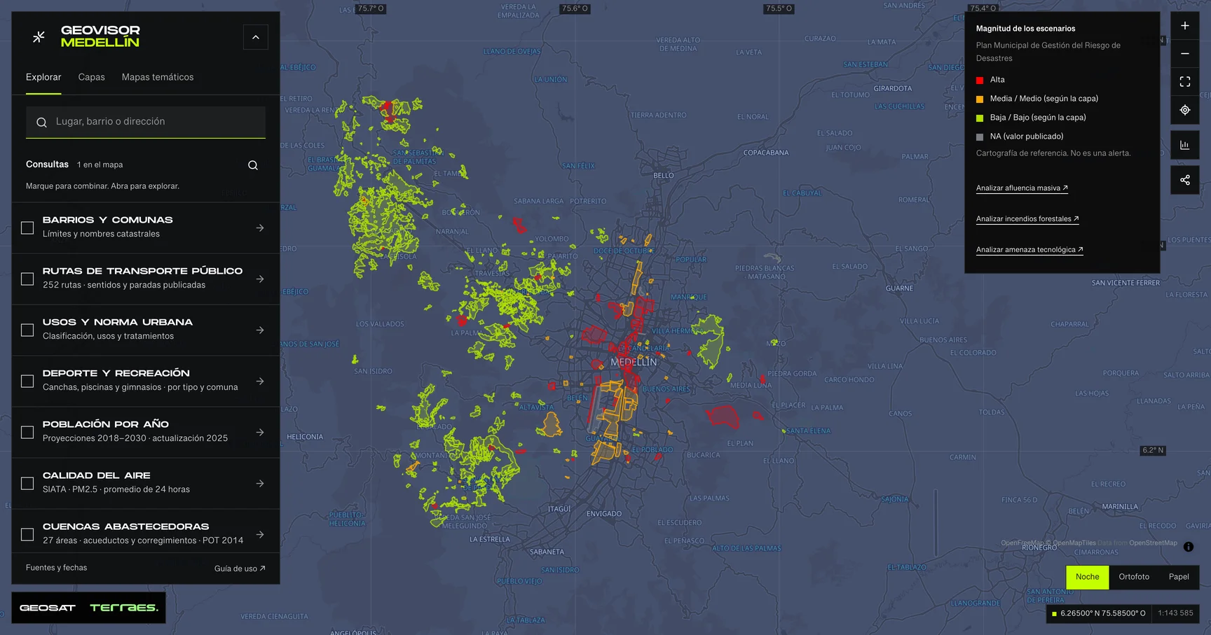
Explore 716 flood-hazard and 2,376 landslide-hazard polygons using the four degrees in the official land-use-plan legend: very low, low, medium and high. The torrent-flow layer adds 115 polygons with its own three-degree blue legend. Three Municipal Disaster Risk Management Plan layers add 507 scenario polygons: 63 mass-gathering, 409 wildfire and 35 technological-hazard records, each with its published magnitude vocabulary; seismic susceptibility from the same plan adds 40 polygons in seven acceleration ranges. Community preparedness adds 39 meeting points and 101 evacuation routes as planning reference, never joined automatically, plus 11 SIATA sirens and 13 level sensors. DAGRD contributes its 8-agency relief directory, 68 geotechnical monitoring instruments, 237 studies from 1984 to 2023, 129 mitigation works from 2016 to 2022 and 2,588 geological-unit polygons. Also inspect areas with risk conditions and non-mitigable high risk in their separate layer. Review categories, dates and geometry while distinguishing hazard, risk and recorded events.
The hazard layer refers to the land-use plan adopted under Agreement 48 of 2014. Flood and landslide records state an April 30, 2026 update; torrent-flow records include April and July 2026 dates; metadata retains a 2016 revision and an earlier count. Risk conditions reference June 18, 2021. Of the 507 risk-management plan scenarios, wildfire is published under CC BY-SA 4.0 with 2015 creation; mass gatherings and technological hazard publish no dates or license. Preparedness points and routes also publish no dates or license, and confirm neither capacity nor safety during an emergency. DAGRD sirens, sensors, instruments, studies, works, relief sites and geological units also publish no dates or license; their readings, statuses and phones are references, not diagnoses, operational availability or current assessments. These are different sources and dates. They are not warnings, events, property assessments or a complete hazard inventory. Consult Planning and the official adopted map for authoritative decisions.
Compare annual public investment across 16 urban districts and 5 rural districts from 2008 to 2024: 357 values published by the Treasury. Explore annual maps and each area’s trend.
Reference publication retrieved in September 2026: all 21 areas and 357 annual values, all present. Figures are retained as published by the service, in pesos with no declared monetary unit; 2025 is not published. Comparing years assumes nominal pesos with no published adjustment. Aggregated fiscal reference, not audited budget execution or the current budget.
Explore 10 epidemiological series by area: dengue, hepatitis A, suicide attempts, mortality, natality, mumps, whooping cough, tuberculosis, chickenpox and gender-based violence, from 2008 to 2022 depending on the event. Annual maps with counts and rates per 100,000 inhabitants: 5,808 values published by the Health Secretariat.
Reference epidemiological surveillance retrieved in September 2026: SIVIGILA notifications with probable or confirmed diagnosis. All 10 series end in 2022 although the layers are titled “vigente”; no dates or reuse license are published. Code 99 aggregates cases with no assigned territory in a minimal polygon in La Candelaria. Aggregated reference by area, not diagnosis or individual risk.
Also compare 2024 AM/PM school meals, enrollment, passing, failing and dropout counts in two layers with 779 records each. Explore 248 higher-education and vocational-training records in a separate layer. Locate public and non-public school sites, inspect their parent establishment and compare loaded records by sector, service, district or neighborhood. Use the analysis tools to explore sites within an area or near a point.
School records include a 2024 reference year. Counts do not measure educational quality or current vacancies. Published zeros are retained; do not sum overlapping layers as unique sites or students. The higher-education and training layer does not declare a global update date; its 248 records do not equal 248 universities. Check each record’s reference year: the service does not declare an update date. Records count sites, not unique institutions; several sites may share a location. Published status does not confirm current service, vacancies or enrollment. Proximity is measured in a straight line, not as walking time.
Inspect urban and rural blocks, land footprints and buildings in small viewports, without parcel identifiers or owner information.
Geometries are for reference and do not certify legal boundaries. Construction features represent floor levels or improvements and can overlap: record counts are not unique building counts. The source does not declare an update date. Market prices are not shown and valuation zones are not interpreted as sale prices.
Explore routes and stops published by Open Data Metro Medellín for service areas 3 and 6. Find a route, choose an itinerary and inspect its stops on the map.
Reference mapping: the operator’s metadata is dated July 29, 2021. Retrieving the service now does not confirm current operation, timetables, frequency or vehicle locations. Check with the operator before travelling.
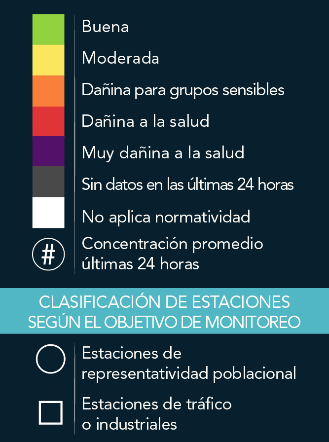
Explore SIATA’s population-representative PM2.5 stations within the Medellín map extent and neighboring municipalities. Inspect the mean concentration over the last 24 hours, published classification and each station’s update time.
Rolling 24-hour means in µg/m³, not instantaneous readings or ICA index values. Provisional SIATA/AMVA operational data, subject to validation. The layer does not represent every network or a uniform neighborhood concentration. Queried every five minutes while visible; source updates older than 30 minutes are marked as old. Rainfall, forecasts and emergency alerts are not included.
Also inspect 36 rural treatment plants, 26 substations and planning water, sewerage, gas and energy networks within the visible area. Explore the 76 rural water-intake records published by Medellín and 174 sanitary-perimeter polygons from its land-use plan. Find a water system by name, compare intake types and catchments, or distinguish EPM and other-entity sanitary-coverage categories on the map. Inspect individual records and compare this reference with the drainage network.
Historical inventories, not current water availability, outages or service quality. Intake records retain update years from 2003 to 2019; their metadata describes a June 2020 revision. Two El Hato points are in Bello and eight records have no water-system name. Polygons describe coverage and potential coverage under the 2014 land-use plan: all report December 17, 2014, while metadata states a March 19, 2015 revision. They do not certify a property’s connection, service feasibility or continuity. Records are not unique water systems or served households; selected areas do not measure effective population coverage.
Explore the 2025 release of 2018–2030 projections by district and rural district, select a year and inspect each area.
DANE–Medellín update of July 30, 2025, based on Census 2018. Urban and rural components are summed for each rural district. Values are estimates for June 30 of each year, not observed counts. Boundaries come from the 2014 administrative layer. A map self-intersection in La América was repaired without changing attributes and with an area change below 0.01%.
Explore 397 mapped records of designated cultural assets (BIC), valued heritage represented as points, paths and polygons, and 18 influence zones. Compare architectural, urban, landscape and archaeological groups, inspect names and locate nearby heritage.
POT heritage reference retrieved on September 26, 2026. The BIC layer identifies designated assets; the three valued-heritage layers do not establish BIC designation, and influence zones describe their surroundings, not additional assets. Do not add layers as unique properties: records may overlap or represent the same place. The service adoption and update fields state December 17, 2014; the BIC metadata describes a June 17, 2021 update. This discrepancy prevents assigning a single dataset date or certifying current designation. Check the applicable instrument with Planning. Published names and categories are retained; the analysis group unifies the spelling “Arquitectonico”. Geometries are simplified by up to 0.5 m with a maximum 1% area change. A missing feature does not establish absence of protection.
Explore all 92 attractions in Medellín’s tourism inventory and three visitor information points published by the District. Find museums, theaters, parks, hills, monuments and places of interest by name, type, district and neighborhood. Compare the 32 published categories, inspect each record or select places near an area.
Reference inventories retrieved on September 27, 2026. Attractions come from the 2019 inventory with attributes added in 2024: metadata states an August 18, 2024 revision, while map-service records state October 17, 2024. Visitor information points have no declared update date. Locations represent places, not their entrances, and do not confirm current opening, hours, prices, accessibility or operation. Records may also appear in heritage, library or public-space layers: do not add layers as unique places. Published website links are omitted because some were associated with different places.
Explore points from the SGC national inventory within the query area. Compare published types and subtypes and open the result source. This reference complements municipal hazard layers with a different scope.
National historical inventory, not an alert or a current hazard map. The service publishes no occurrence or update date per record. Queries show points intersecting the visible area, which may include neighboring municipalities; this is not an exhaustive municipal count. Empty results do not establish absence of movements or risk. Confirm current conditions with the local authority.
Query IGAC polygons around Medellín. Select a territory to read its name, code, category and legal reference. Use the name legend and code filter to distinguish the municipality or district from departments and neighbors also present in the view.
Territorial reference for the visible area: includes departments and neighboring municipalities or districts, with overlapping polygons. Do not add their areas or interpret results as a municipal count. Published categories: 0 department, 1 municipality, 2 district, 3 uncategorized; other codes are retained without a verified definition. Territorial codes remain text; they are not parcel identifiers. Depto and the legal reference are source attributes, not certification of administrative hierarchy or legal validity. Update date not declared. Geometries are generalized by zoom level and coordinates rounded for display; unsuitable for exact positioning, measuring areas or distances, or resolving boundaries. Credit IGAC and identify these changes when reusing.
Explore registered protected areas around Medellín. Compare management categories and inspect names, published status, environmental authorities and enrollment and registration dates. This national reference differs from environmental layers in the land-use plan; each record links to its official entry.
Copy of the official download retrieved on 5 October 2026 (Colombia), not a live query. Selected by bounding boxes within the query area: may include neighbors and polygons that do not intersect the selected point; not a municipal inventory. Enrollment and registration are RUNAP dates, not update, designation or public-opening dates. Overall data date not declared; missing-date markers NaT are omitted from the record. Components and rings are retained; geographic MAGNA coordinates rounded to five decimals for display (small rings retain original precision if rounding would collapse or reverse them), without geodetic adjustment or a guarantee of topological precision. Unsuitable for boundary surveys or precision measurement. Areas may overlap: do not add them or interpret an empty query as absence of protection. Confirm current acts, boundaries and conditions with the environmental authority. GeoSAT adaptation under CC BY-SA 4.0: credit Parques Nacionales, identify changes and retain the same license when redistributing adaptations.
Explore the national agricultural frontier around Medellín. Select a polygon to read its published municipality, department and codes. The legend distinguishes municipalities; filter cod_dane_mpio with 05001 to query Medellín polygons received in that area. This rural reference complements the land-use plan without replacing its permitted uses or identifying suitability for a crop.
Indicative reference at 1:100,000 scale, version 4.1 according to the service; not crop suitability, land-use permission or a parcel assessment. SIPRA warns against use for financial, credit or parcel-planning decisions. The metadata linked by SIPRA is titled June 2025 but lists creation on 2026-03-22 and publication/revision on 2025-05-29: no dataset-wide date is assigned. The methodology aggregates patches larger than 25 ha within 100 m and fills holes smaller than 25 ha. The viewer also generalizes geometry by zoom and rounds coordinates; do not measure areas or settle boundaries with it. Queried polygons may include neighboring municipalities and are not a complete municipal inventory. Empty results do not establish absence of restrictions. Department names and codes remain as published, without validating administrative hierarchy; municipal codes do not identify parcels. This layer does not distinguish conditioned and unconditioned agricultural frontier. Public use with UPRA attribution under its metadata terms; identify the display adaptation and consult the source and authorities for specific decisions.
Explore 866,296 reported accesses for Medellín as of 31 March 2026. The preliminary sum covers reported segments; additional corporate accesses (117) are included when reported. Select the municipality to inspect available segments and export the record with its source. These are not people, homes or unique subscribers; they do not indicate address-level availability.
Fixed internet accesses reported for the first quarter of 2026, as of 31 March. The series is preliminary and subject to revision. The sum covers reported segments; operator internal use and additional corporate accesses (117) are included when reported and shown separately. Accesses do not equal people, homes or unique subscribers. The municipal boundary locates the statistic; it does not describe the network or guarantee service at an address. A segment without a reported record is not treated as zero. Data retrieved from Postdata, Communications Regulation Commission; source extraction 30 June 2026, retrieved 9 October 2026.
MinTIC publishes 761,781 fixed internet accesses for Medellín in 2023-Q3. Open the map and select the municipality to inspect the total and residential strata 1–6, corporate, unclassified and internal-use segments. In Thematic maps, choose each count and export the record with its source. This is a historical municipal reference; it cannot verify current service at an address.
Historical MinTIC reference for 2023-Q3, the latest quarter present in dataset n48w-gutb retrieved on 6 October 2026. Data load: 23 February 2024; not current connectivity. GeoSAT sums reported accesses by municipality and segment, without counting rows as subscribers. The total includes corporate, residential strata 1–6, unclassified and operator internal-use segments. A category with no rows contributes zero only to this published aggregate: it does not establish absence of service. These are accesses, not people, unique households, speed, quality or availability at an address. No penetration rate or population denominator is calculated. The outdated catalog description mentions 2015–2019; this query’s quarter comes from verified rows. The IGAC polygon represents the whole municipality, not the network or its coverage: moving the map does not allocate accesses to neighborhoods or parcels. Current reference geometry generalized to approximately 0.00017 degrees and six decimals, without reconstructing 2023 boundaries; unsuitable for areas or densities. MinTIC data and GeoSAT adaptation CC BY-SA 4.0; IGAC geometry CC BY 4.0.
DANE publishes a multidimensional poverty incidence of 12.8% for Medellín in the 2018 Census. Open the map and select the municipality to inspect the percentage, source and methodology. This is a historical whole-municipality value.
Municipal multidimensional poverty incidence published by DANE from the 2018 National Population and Housing Census. This is a census approximation: five dimensions and 15 deprivation indicators defined at household level, with a weighted threshold of 33.3%. The source refers to actually censused private households and recommends considering census omission. The published percentage is retained without inferring numbers of people or households or recalculating denominators. It is neither current poverty nor an annual series comparable with the Quality of Life Survey IPM or Medellín’s local series. Do not sum or average municipalities to obtain department or national incidence. The current municipal reference polygon neither reconstructs 2018 boundaries nor allocates the value to neighborhoods or parcels. The technical publication is dated 31 January 2020; the retrieval date does not update the census. DANE data and GeoSAT adaptation CC BY 4.0; IGAC geometry CC BY 4.0. The service does not publish the percentage denominator. It cannot determine parcel conditions, benefit eligibility or neighborhood poverty. Reference geometry query parameters are retained in download provenance.
DANE records 785,215 dwellings with water supply in Medellín (2018 Census). Explore available counts with and without service on the map. Historical counts of occupied dwellings with people present; no current address-level availability.
Municipal counts from DANE’s 2018 National Population and Housing Census, for occupied dwellings with people present. The official layer’s categories with and without water supply service are preserved. Their sum is shown as dwellings classified in this publication; people, households, subscribers and all properties are not used as denominators. No rate is calculated and missing values are not replaced with zero. These are 2018 census responses, not current coverage, continuity, water quality or availability at an address. The IGAC polygon identifies the entire municipality: it does not map pipes or allocate dwellings to neighborhoods or parcels. Current reference geometry generalized to approximately 0.00017 degrees and six decimals, without reconstructing 2018 boundaries; unsuitable for area measurements or densities. Copy retrieved on 6 October 2026; the retrieval date does not update the census. DANE, IGAC geometry and GeoSAT adaptation CC BY 4.0.
DANE’s 2018 Census records 794,197 dwellings with electricity in Medellín. Explore electricity, sewerage, piped gas and internet counts. Historical counts of occupied dwellings with people present; no current address-level availability.
Municipal DANE 2018 Census counts for occupied dwellings with people present. Each service retains its with/without counts and its own sum: electricity, sewerage, natural gas connected to the public network, and fixed or mobile internet. Bases differ; no common base is used and services are not added as unique dwellings. The gas layer only provides with/without counts although its dictionary allows “Not reported”; that category is not reconstructed by subtraction. No rates are calculated and nulls are not replaced with zero. These are historical census responses, without current address-level availability, quality or continuity. Dwellings with internet are not the accesses reported by operators to MinTIC. The current IGAC reference polygon identifies the entire municipality, not networks or individual dwellings; it neither reconstructs 2018 boundaries nor allocates counts to neighborhoods or parcels. Geometry generalized to approximately 0.00017 degrees and six decimals, unsuitable for areas or densities. Copies retrieved on 6 October 2026; that date does not update the census. DANE data, IGAC geometry and GeoSAT adaptation CC BY 4.0.
Explore alignments published by INVÍAS around Medellín. Open the map and select a line to inspect its section code, route name, section and administrator, carriageway, category and surface codes. The legend distinguishes routes; choose another attribute in Thematic maps. Filter by section code or exact name and export the record with its source. Records may extend into neighboring municipalities; they are not the complete local street network and do not confirm current availability.
Reference alignments of the road network published by INVÍAS, queried by area and including neighboring areas; not the complete municipal street network or a land-use query. Lines are generalized for display: do not measure distances or use them for navigation or parcel boundaries. No traffic, closures or section inspection dates are provided. The catalog data load is dated 19 September 2026; it does not certify current conditions. Dictionary codes: administrator 1 INVÍAS, 2 ANI, 3 Departmental concession, 4 FINDETER, 5 Disused roads, 6 INVÍAS agreements; carriageway 1 single, 2 dual, 3 not defined; category 1 first order, 2 second order, 3 third order, 4 not defined; surface 1 paved, 2 unpaved, 3 not defined. These attributes do not establish operation, accessibility or completion of works. “Por Defnir” is retained as published by the source and means not defined. A section code can repeat: row identifiers distinguish records, not unique assets. An empty response only means that this query returned no records. INVÍAS and GeoSAT adaptation CC BY-SA 4.0.
Explore bridges in ANI concession projects and toll stations published by INVÍAS around Medellín. Select a point to read its name, project or road section and source. Compare bridges by project and toll stations by section with the legend, or filter by exact name. Both layers are queried by area; toll stations include several administrators, not only ANI.
Infrastructure records within the query area, including neighbors; not a complete municipal inventory or a navigation system. The sources do not provide a status that separates planned, under-construction and operational assets: a point does not establish completed or available infrastructure. No live traffic, closures, accessibility or current toll rates are included. Technical identifiers distinguish source rows, not parcels or unique assets. Catalog dates describe data loads and metadata changes, not inspections of each asset. Credit the respective authority and GeoSAT for the query-point adaptation; reuse under CC BY-SA 4.0.
For 2024, MEN publishes 376,137 people aged 5–16 projected by DANE for Medellín. All 14 verified annual values for 2011–2024 are shown. Open the map, change the year and select the municipality to read its record. Open Thematic maps for the trend and annual table. The figure represents the whole municipality, not the visible map area.
DANE projected population aged 5–16, published by MEN for the whole municipality in 2011–2024. Estimated people, not enrollment, school places, measured school demand or internet availability. Copy retrieved on 5 October 2026 (Colombia); the catalog data load is dated 13 November 2025, not a single DANE release. The source does not document a uniform census basis across the series: differences between years may include methodological revisions and must not be attributed solely to demographic change. No rate or denominator is calculated. Codes are padded to five digits and unambiguous thousands separators in 2021 counts are normalized; original values remain in the reference publication. All 14 verified annual values for 2011–2024 are shown. Joined by code to the IGAC reference polygon: historical boundaries are not reconstructed and people are not allocated to neighborhoods or parcels. Geometry generalized by the service to approximately 0.000172 degrees and six decimal places; unsuitable for measurements or densities. MEN CC BY-SA 4.0; IGAC mapping CC BY 4.0; GeoSAT adaptation CC BY-SA 4.0.
For Medellín, the historical MEN series records a total net enrollment rate of 93.58 % and gross rate of 104.12 % in 2024, relative to the population aged 5–16. Explore ten indicators for 2011–2024: total, transition, primary, lower secondary and upper secondary, each with net and gross rates. Open the map, choose Indicator and year, and review the trend and annual table. All 140 indicator-year values are reported in the retrieved copy. These are historical municipal rates, not available school places or current figures.
Historical municipal enrollment rates published by MEN for 2011–2024, retained as percentages without recalculating denominators or capping values at 100. They do not measure school places, available capacity or school operation. Missing data remain without a value and are not replaced with zero. The source does not document a uniform population-projection edition across the series: changes can include methodological revisions. Differences are expressed in percentage points. The retrieval date does not update the indicator year. The polygon represents the whole municipality, not its distribution by neighborhoods or parcels. Rates and GeoSAT adaptation CC BY-SA 4.0; IGAC mapping CC BY 4.0. Reference geometry generalized by the service to approximately 0.000172 degrees and six decimal places. The reference boundary does not reconstruct each year’s boundaries and is unsuitable for measuring areas or densities.
REPS records 1,200 IPS sites in Medellín at 12 March 2026. Open the map and select the municipality to inspect total, public, private and mixed counts. In Thematic maps, choose each count and export the record with its source. These are municipal figures, not site locations or availability of care.
GeoSAT count of distinct site habilitation codes in REPS, restricted to the healthcare institutions (IPS) class and grouped by site municipality and legal nature. Published cutoff: 12 March 2026; catalog data load: 17 April 2026; copy retrieved: 6 October 2026. The table also includes independent practitioners and other classes, which are excluded. These are registered sites, not unique institutions, hospitals, beds, available capacity, appointments or certification of current operation. No rate or denominator is used. An absent category is counted as zero only within the complete queried aggregate. No site locations are provided: the IGAC polygon represents the whole municipality; moving the map does not change the count or allocate it to neighborhoods. Reference geometry generalized to approximately 0.000172 degrees and six decimals, mapping date undeclared; unsuitable for area measurements or densities. No personal names, IDs, addresses or contacts are published. MinSalud data and GeoSAT adaptation CC BY-SA 4.0; IGAC geometry CC BY 4.0. Consult REPS to verify a specific provider.
The retrieved ANM copy associates 12 distinct file codes with Medellín. Open the map and select the municipality to read the count, file codes and published mineral labels. The catalog data load is dated 18 March 2026. The query uses the whole municipality without locating titles or mines; it does not establish actual extraction or cover all mining titles.
GeoSAT count of distinct file codes associated with the municipality in ANM’s RUCOM mining-title publication. Copy retrieved on 6 October 2026; catalog data load: 18 March 2026, with no record cutoff date. Rows can repeat file codes by mineral or other attributes: each code is counted once per municipality. Do not sum municipalities to obtain a national total. This is not the complete mining-title cadastre, an inventory of operating mines or a production measurement. Inclusion in this copy does not certify current legal status, environmental authorizations or activity: verify the official file and RUCOM. Original mineral labels, including spelling variants, are retained; they are not a standardized classification. Holder names, personal IDs and contact details are excluded. No mining geometries are provided: the IGAC polygon identifies the whole municipality, not a title, plant or extraction area; moving the map does not allocate the count. Reference generalized to approximately 0.000172 degrees and six decimals, mapping date undeclared; unsuitable for area measurements or densities. ANM data and GeoSAT adaptation CC BY-SA 4.0; IGAC geometry CC BY 4.0.
Explore ANLA project records intersecting a Medellín query area. The road connection between the Aburrá and Cauca river valleys example opens file LAM0678, objectid 202. The original note reads “ARCHIVADO”: this is historical published text, not a statement about current operations or permits. Compare sectors and read the project, published act, date and notes. This environmental-monitoring reference is separate from the municipal land-use plan.
Project areas published by ANLA in its “Seguimiento” group, not a municipal land-use plan, parcels, alerts or a current risk assessment. Each geometry is a record: one file may have several areas and acts; do not count records as unique projects or sum their areas as affected municipal land. fec_act_ad is the published act date, not a mapping update, current legal validity or operating status. The source declares neither a mapping scale nor a dataset-wide date. The public item credits ANLA but declares no specific reuse licence; consult the official terms and links without assuming a CC licence. Received EPSG:4326 geometry, transformed by the service from EPSG:4686, is retained without clipping, simplification or additional rounding. Query-window intersections may include areas outside the municipality. Queries are limited to 500 records and 2 MiB; partial, empty or failed responses do not establish the absence of projects or restrictions. Sector retains its official domain code: 101 Hidrocarburos, 102 Infraestructura, 103 Minería, 104 Energía, 105 Agroquímicos, 106 Proyectos Especiales. Notes reproduce historical published text; spaces or null values are missing information, not permissions or absence of restrictions. Confirm the file and applicable acts with ANLA.
Reported accesses by segment · CRC 2026-Q1· 866,296 reported accesses for Medellín · preliminary sum of reported segments; includes 117 when reported; no address-level availability
Population aged 5–16 by year· MEN / DANE 2011–2024 series for Medellín · estimated people across the municipality; not enrollment or school places
Net and gross enrollment rates by year· MEN rates for Medellín, 2011–2024 · ten indicators by education level and year; municipal percentages, not available school places
File codes and minerals published in RUCOM· Count of 12 distinct file codes associated with Medellín in the ANM copy · does not locate mines or certify current operation
Explore ANLA project areas· Open file LAM0678, objectid 202, the Aburrá–Cauca river road connection. The published note “ARCHIVADO” is retained as historical text. The legend distinguishes sectors; the example certifies neither current operations nor permits.
Sources, dates and limits
Each source’s verification date appears in the table. Retrieval time is not the data update date. Small city-wide layers use the full extent; larger layers depend on the visible area. Reference publications retain their original retrieval date. Each page contains up to 500 features: up to 2 MiB for external services and 4 MiB for local publications. Reference publications load matching pages, up to 5,000 features and 8 MiB per query. External services may return partial samples, identified in the viewer.
Layer and source
Data date
Reuse
Wetlands and lagoons · 2014 planning referenceDistrito Especial de Ciencia Tecnología e Innovación de Medellín · GeoMedellín · Departamento Administrativo de Planeación · Subdirección de Planeación Territorial y Estratégica de Ciudad · Adaptación GeoSAT: selección de atributos, fechas UTC ISO, geometrías WGS84 originales sin simplificar y área cartográfica calculada en EPSG:9377
113 polygons from the land-use plan’s ecological-structure map: five have published names and 108 do not. Metadata lists the five known water bodies, but its geometric count also states 113. These are not 113 distinct wetlands verified in the field. The five named records already appear in Reference water bodies: do not add the two layers as separate sites. All records state adoption and update on December 17, 2014; metadata declares a March 19, 2015 revision. Complete original geometry is retained. Calculated area describes the mapped footprint, not available water, ecological condition or current boundaries. Wetland setbacks are not included, and public access is not established; consult the adopted map and competent authority.
Bus stops · route and direction recordsDistrito Especial de Ciencia Tecnología e Innovación de Medellín · GeoMedellín · Dato proporcionado por Departamento Administrativo de Planeación · Subdirección de Planeación Territorial y Estratégica de Ciudad · Secretaría de Movilidad. Adaptación GeoSAT: selección de atributos, consulta por ruta y transformación WGS84 del servicio municipal. CC BY-SA 4.0.
At verification on September 28, 2026, 10,043 records linked 3,590 physical stop identifiers to 247 of the viewer’s 252 routes. Records join by route identifier and published direction; the same physical stop can occur on several routes. Stops exist for 493 of 504 paths: five routes and one additional direction have no matching records. Record dates range from August 1, 2018 to February 27, 2026; 6,882 records retain the 2018 date. Published numbering can continue between directions, skip or repeat: records are neither renumbered nor deduplicated. The source describes approximate positions derived from grouped CAD points. Those positions remain unchanged even where they differ from paths; there are no timetables, arrivals, verified accessibility or live vehicles. Queries cover the visible area and at most 500 records; select a route to review its stops. Dataset metadata declares CC BY-SA 4.0; its edit date does not replace individual record dates.
Sidewalks · municipal inventoryDistrito Especial de Ciencia Tecnología e Innovación de Medellín · GeoMedellín · Consulta GeoSAT por extensión visible al servicio municipal en WGS84
The service publishes 42,965 sidewalk traces with element and segment identifiers but no declared names or domains. Zoom in to query up to 500 records per area; results may be partial. Geometry and digitized order do not establish walking direction or a continuous route. The source declares no update date or verifiable units for width, height or length, so those values are not shown. This inventory does not establish current continuity, ramps, slopes, obstacles, safety or accessibility. The service declares no specific reuse license.
No dataset-wide date declared; check individual recordsSource checked:
Water-supply catchments · 2014 land-use planDistrito Especial de Ciencia Tecnología e Innovación de Medellín - GeoMedellín - Dato proporcionado por Departamento Administrativo de Planeación - Subdirección de Planeación Territorial y Estratégica de Ciudad · Adaptación GeoSAT: selección de atributos y fechas ISO; conversión WGS84 del servidor original, sin redondeo ni simplificación de geometrías
27 rural water-supply catchments and subcatchments published for the 2014 land-use plan at 1:5,000 scale. Every record has adoption and update dates of December 17, 2014; the metadata was published and revised on March 19, 2015. Every component, hole and WGS84 coordinate returned by the server is preserved. Five records do not name an aqueduct and two do not name a rural district. These areas relate to reserves and aqueducts in other layers: their areas should not be added as independent coverage. They do not describe flow, water quality or current water-supply operation. For regulatory decisions consult the adopted map of Agreement 48 of 2014.
Ecoparks · 2024 management inventoryDistrito Especial de Ciencia Tecnología e Innovación de Medellín - GeoMedellín - Dato proporcionado por Secretaría de Medio Ambiente - Subsecretaría de Recursos Naturales Renovables · Adaptación GeoSAT: selección de atributos y fechas ISO; conversión WGS84 del servidor original, sin redondeo ni simplificación de geometrías
81 ecopark records managed by the Environment Secretariat, from the September 30, 2024 version stated in the metadata, at 1:500 scale. Individual records have no dates. The published action is Mantenimiento (maintenance) in 74 records, Generación (creation) in five and unspecified in two; these categories do not establish current work, completion or public opening. Every component, hole and original server WGS84 coordinate is preserved. This layer overlaps the existing park inventory: these are not 81 additional parks, and their areas should not be added across inventories. Streams, addresses and categories retain published wording; they do not establish opening hours, trails, accessibility or visitor conditions.
Taxi stands · published validity year 2025Distrito Especial de Ciencia Tecnología e Innovación de Medellín · GeoMedellín · Adaptación GeoSAT: selección y nombres de atributos; categorías de dominios y leyendas oficiales; geometría WGS84 del servicio, sin simplificación, con al menos siete decimales
192 taxi stands with published validity year 2025 and “Vigente” status in the retrieved inventory. Administrative instruments retain their source text. Capacity ranges from 2 to 29 vehicles per stand, not available taxis or spaces. No review date is declared; the published status does not establish current validity. No fares or live service information are provided. The service declares no specific reuse license.
No dataset-wide date declared; check individual recordsSource checked:
Traffic-light crossings · municipal inventoryDistrito Especial de Ciencia Tecnología e Innovación de Medellín · GeoMedellín · Adaptación GeoSAT: selección y nombres de atributos; categorías de dominios y leyendas oficiales; geometría WGS84 del servicio, sin simplificación, con al menos siete decimales
724 traffic-light crossing records with published codes, addresses and locations. These are crossings, not a count of signal heads or controllers. One inventory representation is used; the alternative 715-record service is not added. The source declares no update date, phases, timings, faults or live operational status. The service declares no specific reuse license.
No dataset-wide date declared; check individual recordsSource checked:
Tactical urbanism · published interventionsDistrito Especial de Ciencia Tecnología e Innovación de Medellín · GeoMedellín · Adaptación GeoSAT: selección y nombres de atributos; categorías de dominios y leyendas oficiales; geometría WGS84 del servicio, sin simplificación, con al menos siete decimales
120 intervention polygons published by the Human Mobility office. “Consolidado”, “Para consolidar”, “Para mantenimiento” and “Para retirar” describe the inventory, not a current inspection. Construction years remain categories: 119 records state 2016–2019 and one states 2028; that anomalous value is not corrected or treated as proof of a future project. No review date, impact measurement or accessibility assessment is declared. The service declares no specific reuse license.
Mass-transit stations · municipal referenceDistrito Especial de Ciencia Tecnología e Innovación de Medellín · GeoMedellín · Adaptación GeoSAT: selección y nombres de atributos; categorías de dominios y leyendas oficiales; geometría WGS84 del servicio, sin simplificación, con al menos siete decimales
81 station and stop records: 77 marked “Existente” and four “Proyectado” by the source. Metro, Metrocable, Metroplús and Tram types are decoded from the official legend; statuses use the service domain. Every record lacks an update date. Neighboring-municipality stations and records by line are retained; these are not 81 unique Medellín stations or a current operating map. No frequencies, timetables, vehicles or verified accessibility are published. The service declares no specific reuse license.
Mass-transit lines · municipal referenceDistrito Especial de Ciencia Tecnología e Innovación de Medellín · GeoMedellín · Adaptación GeoSAT: selección y nombres de atributos; categorías de dominios y leyendas oficiales; geometría WGS84 del servicio, sin simplificación, con al menos siete decimales
14 municipal paths with 13 line names: 12 records marked “Existente”, one “En Ejecución” and one “En Estudio” by the published domain. Types are decoded from the official legend. Every record lacks an update date; statuses do not establish current operations or construction progress. Geometry retains separate parts and does not by itself define travel direction, stops or navigable itineraries. This is not live train or cable-car tracking. The service declares no specific reuse license.
Crossing structures and bridges · municipal inventoryDistrito Especial de Ciencia Tecnología e Innovación de Medellín · GeoMedellín · Adaptación GeoSAT: selección y nombres de atributos; categorías de dominios y leyendas oficiales; geometría WGS84 del servicio, sin simplificación, con al menos siete decimales
1,993 records: 608 pedestrian bridges, 474 road bridges and 911 buried conduits according to their published category. The service’s actual “id” identifier and every geometry part are retained. These are not 1,993 traversable bridges or a safety assessment. Dates remain source text: 205 state 1901, 180 lack a date and one states September 30, 2026, after retrieval; one construction year states 1205. These anomalies prevent assigning an overall update date. The service declares no specific reuse license.
No dataset-wide date declared; check individual recordsSource checked:
Road hierarchy · 2014 planDistrito Especial de Ciencia Tecnología e Innovación de Medellín · GeoMedellín · Adaptación GeoSAT: selección y nombres de atributos; categorías de dominios y leyendas oficiales; geometría WGS84 del servicio, sin simplificación, con al menos siete decimales
1,030 road-hierarchy paths, including railway, with urban or rural classification and planning statuses “Existente”, “Ampliación” and “Proyectado”. All publish adoption and update dates of December 17, 2014. The archive retains connections outside Medellín; queries return paths intersecting the requested extent. This does not show traffic, closures, open lanes or current navigability. Geometries are neither clipped nor dissolved for length sums. The service declares no specific reuse license.
Reference pedestrian network · 2014 planDistrito Especial de Ciencia Tecnología e Innovación de Medellín · GeoMedellín · Adaptación GeoSAT: selección y nombres de atributos; categorías de dominios y leyendas oficiales; geometría WGS84 del servicio, sin simplificación, con al menos siete decimales
1,314 segments from the pedestrian-network service, with published categories such as circuits, connectors, footpaths and roads. The source includes regional connections outside Medellín: these are not 1,314 sidewalks exclusive to the district. Every record has adoption and update dates of December 17, 2014; “Existente” and “Proyectado” describe that plan. Planning intent does not certify ramps, pedestrian continuity or current reduced-mobility access. No safe routing is calculated. The service declares no specific reuse license.
Rural road-corridor reserves · 2014 planDistrito Especial de Ciencia Tecnología e Innovación de Medellín · GeoMedellín · Adaptación GeoSAT: selección y nombres de atributos; categorías de dominios y leyendas oficiales; geometría WGS84 del servicio, sin simplificación, con al menos siete decimales
Four rural reservation or exclusion corridor polygons, with adoption and update dates of December 17, 2014. Published names and complete boundaries are retained. They are not drivable road widths, certified affected parcels or completed works; applying restrictions requires the plan and relevant instruments. The service declares no specific reuse license.
Free Wi-Fi sites · municipal inventoryDistrito Especial de Ciencia Tecnología e Innovación de Medellín · GeoMedellín · Adaptación GeoSAT: selección y nombres de atributos públicos; geometría WGS84 transformada por el servicio de origen sin simplificación
The source declares no update date. Points do not confirm a working connection today, speed, signal range, capacity or access conditions. Territory codes are retained, including one SN01 record without a declared equivalent. Two records share coordinates. A point does not represent the area covered by a signal. The service declares no specific reuse license.
No dataset-wide date declared; check individual recordsSource checked:
Enterprise development centers · CEDEZODistrito Especial de Ciencia Tecnología e Innovación de Medellín · GeoMedellín · Adaptación GeoSAT: selección y nombres de atributos públicos; geometría WGS84 transformada por el servicio de origen sin simplificación · Secretaría de Desarrollo Económico · Subsecretaría de Creación y Fortalecimiento Empresarial
16 CEDEZO centers with names and location references published by Economic Development. No update date is declared; records do not confirm current opening, advice, requirements or operation. Source coordinator names and phone numbers are omitted. Centers can share premises with other services: do not sum layers as unique buildings. No specific reuse license is stated.
No dataset-wide date declared; check individual recordsSource checked:
Employment offices · OPEDistrito Especial de Ciencia Tecnología e Innovación de Medellín · GeoMedellín · Adaptación GeoSAT: selección y nombres de atributos públicos; geometría WGS84 transformada por el servicio de origen sin simplificación · Secretaría de Desarrollo Económico · Subsecretaría de Creación y Fortalecimiento Empresarial
17 OPE records with published descriptions of guidance, résumé and application services. No update date is declared. The layer contains no jobseeker records, vacancies, appointments, places or confirmation of current services. Points can coincide with CEDEZO or other offices. Phone numbers and unverified hours are omitted. No specific reuse license is stated.
No dataset-wide date declared; check individual recordsSource checked:
AM/PM school meals · 2024 recordsDistrito Especial de Ciencia Tecnología e Innovación de Medellín · GeoMedellín · Adaptación GeoSAT: selección y nombres de atributos públicos; geometría WGS84 transformada por el servicio de origen sin simplificación · Secretaría de Educación
779 school-site records for the published 2024 period. Metadata defines the measure as students receiving the AM/PM food strategy within the school. All 303 published zeros are retained; the source does not explain whether each zero means no beneficiaries or missing reporting. Other measures with undocumented abbreviations are omitted. Locations repeat the educational inventory and outcomes layer: do not sum these layers as unique sites or students. Records do not confirm places, menus, eligibility or current provision. No precise update date or specific reuse license is declared.
No dataset-wide date declared; check individual recordsSource checked:
Enrollment and school outcomes · 2024 recordsDistrito Especial de Ciencia Tecnología e Innovación de Medellín · GeoMedellín · Adaptación GeoSAT: selección y nombres de atributos públicos; geometría WGS84 transformada por el servicio de origen sin simplificación · Secretaría de Educación
779 school-site records for the published 2024 period, with enrollment, passing, failing and dropout totals. In every record, the three outcomes sum to enrollment; source rates are omitted and percentage averages are not presented. There are 58 zero-enrollment records; these do not establish closure or no actual students. There are 776 distinct names and 777 distinct coordinates: records are not deduplicated by name or position. Do not sum this layer with school meals or sites as unique institutions. Counts describe the 2024 record, not educational quality, causation, available places or current enrollment. No precise update date or specific reuse license is declared.
No dataset-wide date declared; check individual recordsSource checked:
Rural land cover · 2021 orthophotoDistrito de Medellín · Departamento Administrativo de Planeación · Nombres de clase Corine Land Cover: IDEAM · Consulta GeoSAT por extensión visible al servicio municipal en WGS84
The municipal source contains 19,221 rural polygons and classifies up to level 4. This viewer gives verified level-three code names cross-checked against IDEAM’s official legend; level-four and current-use codes are not interpreted without a domain. Queries cover the nearby visible area and can be partial. Published area describes the full polygon, not its viewport intersection. Orthophotography is from 2021 and does not establish current cover.
Sampling sites · San Antonio de PradoDistrito de Medellín · Secretaría de Medio Ambiente · Adaptación GeoSAT: atributos seleccionados, fechas UTC en formato ISO y coordenadas WGS84 redondeadas a siete decimales, sin simplificación
75 San Antonio de Prado monitoring sites. The most recent site date in the attributes is January 22, 2018; quality categories are published for the 2013, 2015 and 2017 campaigns. Text categories, including “N/A” and “No observation”, are retained without treating zero-valued numeric indices as measurements. These records do not describe current quality or drinking safety. The service states no specific reuse license.
Stream setback quality · historicalDistrito de Medellín · Secretaría de Medio Ambiente · Adaptación GeoSAT: atributos seleccionados, fechas UTC en formato ISO y coordenadas WGS84 redondeadas a siete decimales, sin simplificación
74 polygons with published IIR categories for 2012, 2013, 2015 and 2017, plus five pressure fields. “N/A”, “No information” and spelling variants remain as published. Pressures describe a historical assessment, not currently verified conditions or a current legal setback boundary. Geometry retains components and holes without simplification. The service states no specific reuse license.
No dataset-wide date declared; check individual recordsSource checked:
Seed-source trees · reservesDistrito de Medellín · Secretaría de Medio Ambiente · Subsecretaría de Recursos Naturales Renovables · Adaptación GeoSAT: atributos seleccionados, fechas UTC en formato ISO y coordenadas WGS84 redondeadas a siete decimales, sin simplificación
89 trees recorded inside project reserves; the service describes work from March 2024 to May 2025. Individual survey dates run from May 31, 2024 to May 15, 2025. Tree codes are not unique, so each record retains its source ID. Diameter at breast height and tree height are published measurements, not current values. Property names and free-text observations are excluded. Location does not grant access. The service states no specific reuse license.
Forest interventions · Más BosquesDistrito de Medellín · Secretaría de Medio Ambiente · Subsecretaría de Recursos Naturales Renovables · Adaptación GeoSAT: atributos seleccionados, fechas UTC en formato ISO y coordenadas WGS84 redondeadas a siete decimales, sin simplificación
160 Más Bosques para Medellín project polygons. The service describes interventions and maintenance from 2009 through May 29, 2025; published individual establishment dates run from 2010 to May 2025. Planted-tree counts and hectares are inventory attributes, not survival counts or current canopy. Farm and owner names and free-text observations are excluded. Full unsimplified geometries; the service states no specific reuse license.
Environmental zoning · 2014 land-use planDistrito de Medellín · Departamento Administrativo de Planeación · Adaptación GeoSAT: atributos seleccionados, fechas UTC en formato ISO y coordenadas WGS84 redondeadas a siete decimales, sin simplificación
207 land-use-plan zoning segments, adopted according to the service on December 17, 2014. The same protected area appears across several polygons; this count does not measure independent areas and differs from the ten designated-area records. Some polygons extend beyond Medellín. All components and holes are retained, while internal zoning IDs and derived areas are excluded. This is reference mapping, not certification of current rules. The service states no specific reuse license.
The service contains 776 polygons with an adoption date of December 17, 2014. This layer queries only the visible area at neighborhood scale and can be truncated at 500 records or 2 MiB per response. “Proposed link” and “Proposed node” are planning categories, not completed works; “current” also reflects the historical land-use-plan classification. It does not establish observed ecological connectivity today or current rules. No specific reuse license is stated.
Strategic intervention areas · 2014 planDistrito Especial de Ciencia Tecnología e Innovación de Medellín · GeoMedellín · Departamento Administrativo de Planeación · Adaptación GeoSAT: atributos seleccionados; transformación WGS84 del servicio; simplificación de hasta 0,5 m con preservación de componentes y huecos; precisión de al menos siete decimales
Twelve strategic intervention polygons from the land-use plan adopted through Agreement 48 of 2014: MEDRío, the urban-rural edge and cross-city areas. Published names and classifications are retained. Record adoption and update dates are December 17, 2014; retrieval in 2026 does not update the plan or establish project delivery. These are not live works or regulatory certification. The public service declares no specific reuse license.
Urban and rural centers · 2014 planDistrito Especial de Ciencia Tecnología e Innovación de Medellín · GeoMedellín · Departamento Administrativo de Planeación · Adaptación GeoSAT: atributos seleccionados; transformación WGS84 del servicio; simplificación de hasta 0,5 m con preservación de componentes y huecos; precisión de al menos siete decimales
78 centers from the 2014 land-use plan with published hierarchy, character, order, action and status. The service’s three representations contain the same 78 IDs and attributes; records are included once, with both urban and rural hierarchies. “Consolidada” and other statuses describe that plan, not a current assessment. Adoption and update: December 17, 2014. Boundaries are not neighborhoods or commercial catchments. The public service declares no specific reuse license.
Housing density, floor-area ratio and height · 2014 planDistrito Especial de Ciencia Tecnología e Innovación de Medellín · GeoMedellín · Departamento Administrativo de Planeación · Adaptación GeoSAT: atributos seleccionados; transformación WGS84 del servicio; simplificación de hasta 0,5 m con preservación de componentes y huecos; precisión de al menos siete decimales
386 municipal urban and urban-expansion polygons, with published adoption and update dates of December 17, 2014. Density, floor-area-ratio and height services repeat the same IDs and attributes and are included once. Their scope differs from the metropolitan treatment source’s 522 records, retained separately. Maximum housing density: dwellings per hectare; floor-area ratio: permitted floor m² per land m²; both use net land area except Development treatment, which uses gross area. Numeric height is in floors. “N/A” and “Variable 1/2/3” remain categories and are not converted to zero. These are published planning parameters, not population, existing dwellings or measured building heights. Means describe polygons with values, without area weighting; they do not calculate total development capacity. Application depends on Agreement 48 of 2014 and applicable rules; the viewer does not certify a property’s development rights. The service declares no specific reuse license.
Rural agricultural district · 2014 planDistrito Especial de Ciencia Tecnología e Innovación de Medellín · GeoMedellín · Departamento Administrativo de Planeación · Adaptación GeoSAT: atributos seleccionados; transformación WGS84 del servicio; simplificación de hasta 0,5 m con preservación de componentes y huecos; precisión de al menos siete decimales
69 polygon records of the rural agricultural district in the 2014 plan, organized by rural district and treatment code; these are not 69 distinct districts. Every geometry component and hole is retained. Published adoption and update: December 17, 2014. These are not parcels, farms, current crops or cadastral boundaries. The public service declares no specific reuse license.
Rural planning units · 2014 planDistrito Especial de Ciencia Tecnología e Innovación de Medellín · GeoMedellín · Departamento Administrativo de Planeación · Adaptación GeoSAT: atributos seleccionados; transformación WGS84 del servicio; simplificación de hasta 0,5 m con preservación de componentes y huecos; precisión de al menos siete decimales
22 rural planning unit polygons with names, codes, classifications and categories published in the 2014 land-use plan. Adoption and update dates are December 17, 2014. Boundaries identify planning instruments; they do not establish subsequent individual adoption, delivery or current status. These are not cadastral boundaries. The public service declares no specific reuse license.
Treatment plants · rural water systemsDistrito Especial de Ciencia Tecnología e Innovación de Medellín · GeoMedellín · Adaptación GeoSAT: selección y nombres de atributos, fechas ISO; geometría WGS84 del servicio sin simplificación · Secretaría de Gestión y Control Territorial · Subsecretaría de Servicios Públicos · Equipo Agua Potable y Saneamiento Básico
36 published drinking-water and wastewater treatment plant locations. Original names, providers, processes and territories are retained; one record lists “Barrio 13 de noviembre” in the territory field. No review date is declared. A location does not confirm operations, capacity, water quality or supply coverage. The service declares no specific reuse license.
No dataset-wide date declared; check individual recordsSource checked:
Postal districts · Medellín and surroundingsDistrito Especial de Ciencia Tecnología e Innovación de Medellín · GeoMedellín · Adaptación GeoSAT: selección y nombres de atributos, fechas ISO; geometría WGS84 del servicio sin simplificación · Subsecretaría de Catastro
The archive retains 59 polygons, including neighboring municipalities; the viewer queries those intersecting its extent. Synchronization on September 28, 2026 does not establish when boundaries were revised. It does not certify deliveries, individual addresses or a postal operator’s coverage. The service declares no specific reuse license.
No dataset-wide date declared; check individual recordsSource checked:
Geodetic control points · 2010–2019 reviewsDistrito Especial de Ciencia Tecnología e Innovación de Medellín · GeoMedellín · Adaptación GeoSAT: selección y nombres de atributos, fechas ISO; geometría WGS84 del servicio sin simplificación
The archive contains 1,089 control points across several municipalities and five origin areas, not an inventory exclusive to Medellín. Recorded reviews span 2010–2019 and 21 points have no date; the published “Disponible” status does not confirm their current condition. Reference locations and areas do not replace official records, transformation parameters or field verification. No specific reuse license is declared.
No dataset-wide date declared; check individual recordsSource checked:
Cartesian-origin areas · MAGNA Aburrá ValleyDistrito Especial de Ciencia Tecnología e Innovación de Medellín · GeoMedellín · Adaptación GeoSAT: selección y nombres de atributos, fechas ISO; geometría WGS84 del servicio sin simplificación
Five published areas: Barbosa, Caldas, Girardota, Medellin 2K and Medellin 5K, including territory beyond the viewer extent. The scale field remains as published, without assigning undocumented accuracy or units. No review date is provided. The polygons do not contain the parameters required to transform coordinates or establish a reference system’s current validity. The service declares no specific reuse license.
No dataset-wide date declared; check individual recordsSource checked:
Electrical substations · 2014 land-use planDistrito Especial de Ciencia Tecnología e Innovación de Medellín · GeoMedellín · Adaptación GeoSAT: selección y nombres de atributos, fechas ISO; geometría WGS84 del servicio sin simplificación
26 published polygons with adoption and update dates of December 17, 2014. The archive includes facilities in neighboring municipalities and retains their full boundaries. Land-use planning reference: it does not establish current operations, power ratings, capacity, ownership, outages or supply coverage. The service declares no specific reuse license.
Main utility networks · 2014 land-use planDistrito Especial de Ciencia Tecnología e Innovación de Medellín · GeoMedellín · Departamento Administrativo de Planeación · Subdirección de Planeación Territorial y Estratégica de Ciudad · Subdirección de Información, Seguimiento y Evaluación · Adaptación GeoSAT: selección de atributos y consulta WGS84 generalizada según la escala
The service publishes 14,629 segments: 12,204 water supply, 2,099 sewerage, 257 gas and 69 energy. Every record has adoption and update dates of December 17, 2014. Zoom in to query up to 500 segments per area; results may be partial. Geometry is queried from the service and generalized for the map scale. This is a planning reference, not a construction drawing or current operational status: it provides no service connections, capacity, pressure, outages or traffic. The service declares no specific reuse license.
Citizen-service offices · referenceDistrito de Medellín · GeoMedellín · Sedes de Atención al Ciudadano · Adaptación GeoSAT: selección de atributos institucionales públicos y normalización de espacios; coordenadas WGS84 transformadas por el servicio de origen, sin simplificación
22 records: 11 citizen-service centers, six MASCERCA offices and five government offices. District values retain the published code. No update date is declared; location does not confirm opening, hours or available procedures.
No dataset-wide date declared; check individual recordsSource checked:
Social inclusion · offices and services inventoryDistrito de Medellín · Secretaría de Inclusión Social, Familia y Derechos Humanos · Adaptación GeoSAT: selección de atributos institucionales públicos y normalización de espacios; coordenadas WGS84 transformadas por el servicio de origen, sin simplificación; categorías originales y registros identificados por capa e ID de origen
96 records across all ten published categories and 86 distinct coordinates; these are not 96 unique buildings. Repeated names and shared locations are retained. Categories describe institutional services, not people. No update date is declared and the inventory does not confirm operation, availability or eligibility.
No dataset-wide date declared; check individual recordsSource checked:
Family commissioners · published locationsDistrito de Medellín · Departamento Administrativo de Planeación · Unidad Comisarías de Familia, Subsecretaría de Gobierno Local y Convivencia, Secretaría de Seguridad y Convivencia · Adaptación GeoSAT: selección de atributos institucionales públicos y normalización de espacios; coordenadas WGS84 transformadas por el servicio de origen, sin simplificación; nombre y dirección separados a partir de la localización publicada
32 records at 27 distinct coordinates, including permanent-service shifts sharing an office. Nine records lack a district and six lack a neighborhood. The description cites Decree 0854 of 2025 without declaring an update date. These points do not delineate jurisdictions or confirm current service. Contacts, responsible persons and observations are omitted.
No dataset-wide date declared; check individual recordsSource checked:
Peace and Human Rights · published officesDistrito de Medellín · Secretaría de Paz y Derechos Humanos · Adaptación GeoSAT: selección de atributos institucionales públicos y normalización de espacios; coordenadas WGS84 transformadas por el servicio de origen, sin simplificación
Ten offices with an address and institutional service description, with no declared update date. Descriptions do not establish current capacity, service or hours. Some offices also appear in other layers; do not add layers as unique places.
No dataset-wide date declared; check individual recordsSource checked:
Guardabosques reserves · water-supply catchmentsDistrito Especial de Ciencia Tecnología e Innovación de Medellín · GeoMedellín · Secretaría de Medio Ambiente · Subsecretaría de Recursos Naturales Renovables · Adaptación GeoSAT: selección de atributos y coordenadas WGS84 redondeadas a siete decimales, sin simplificación
17 reserves acquired to protect catchments supplying community and rural aqueducts. The service description declares a December 10, 2025 update; individual records have no dates. The five rural districts, catchments and subcatchments retain published wording, including “No aplica” and source spelling errors. Geometry retains every component and hole, rounded by less than one centimeter. These are not forest-cover, flow, trail or permitted-access data. The public service declares no specific reuse license.
Designated protected areasDistrito Especial de Ciencia Tecnología e Innovación de Medellín · GeoMedellín · Secretaría de Medio Ambiente · Subsecretaría de Recursos Naturales Renovables · Adaptación GeoSAT: selección de atributos y coordenadas WGS84 redondeadas a siete decimales, sin simplificación
Ten areas associated with Medellín, not ten municipal parks: nine intersect the viewer extent and Alto de San Miguel lies outside it to the south. Polygons spanning neighboring municipalities remain complete. The service declares a November 28, 2025 update; attributes retain RUNAP reports from 2018–2020 and the 2014 land-use plan. Separate metadata retains 11 records and 2018 dates: this publication uses the ten queried records without replacing those dates. Five categories, documents and names remain as published. All components and the Río Nare polygon’s 111 holes are preserved; coordinate rounding is below one centimeter. Full areas are not Medellín totals or certification of legal boundaries or public access.
Higher education and vocational trainingDistrito de Medellín · GeoMedellín · Secretaría de Educación · Adaptación GeoSAT: selección de atributos institucionales públicos, nombre normalizado y coordenadas WGS84 transformadas por el servicio de origen
248 records from the “Instituciones Superiores” service: 215 are classified as vocational training and 33 as other higher-education types. There are 241 names and 229 distinct locations; these are not 248 unique institutions or campuses. The service declares no update date. Points do not confirm current operation, accreditation, programs, admissions, hours or availability.
No dataset-wide date declared; check individual recordsSource checked:
Health facilities · 2014 planDistrito de Medellín · GeoMedellín · Departamento Administrativo de Planeación, Subdirección de Planeación Territorial y Estratégica de Ciudad, Unidad de Planificación Territorial · Adaptación GeoSAT: filtro de la categoría «Equipamiento de Salud», atributos públicos seleccionados y geometrías WGS84 transformadas por el servicio de origen, sin simplificación
99 polygons classified as “Equipamiento de Salud” in the planning map. All publish adoption and update dates of December 17, 2014. Includes projects, parking and historical provider names; it does not establish current operation. Do not count polygons as unique facilities or use this layer to decide where to seek current medical care.
Transport corridors · 2014 land-use planDistrito Especial de Ciencia Tecnología e Innovación de Medellín · GeoMedellín · Departamento Administrativo de Planeación · Subdirección de Planeación Territorial y Estratégica de Ciudad · Unidad de Planificación Territorial · Adaptación GeoSAT: selección de atributos y estados de la leyenda oficial; geometría WGS84 del servicio sin simplificación
94 mapped passenger-transport corridor records from the land-use plan adopted through Agreement 48 of 2014; these are not 94 distinct lines. Published adoption and update dates are December 17, 2014. The official legend classified nine records as existing and 85 as proposed or under study: these are categories of that plan, not a current assessment. They do not establish operations, frequencies, stops, traffic or confirmed project delivery. Published names and paths remain unchanged, including overlapping segments, multipart features and portions beyond the initial viewer extent; summing full lengths does not yield a municipal total or travel itinerary. The public service declares no specific reuse license.
ECAS · classification and material-recovery stationsDistrito de Medellín · Secretaría de Gestión y Control Territorial, Subsecretaría de Servicios Públicos · Adaptación GeoSAT: selección y normalización de atributos públicos de organizaciones y sedes; coordenadas WGS84 transformadas por el servicio de origen, sin simplificación
Municipal inventory retrieved September 28, 2026. The official description mentions 45 active ECAS in 2025, while independent count and ID queries return 46 records. All 46 are shown without asserting current operation. The queried metadata declare no update date or specific license. Several locations belong to the same organization. A location does not confirm public access, accepted materials, hours, capacity or prices; check conditions with the organization before bringing material.
No dataset-wide date declared; check individual recordsSource checked:
Landslide hazard · land-use planDistrito Especial de Ciencia Tecnología e Innovación de Medellín · GeoMedellín · Departamento Administrativo de Planeación · Subdirección de Planeación Territorial y Estratégica de Ciudad · Adaptación GeoSAT: selección de atributos, fechas UTC ISO, WGS84, reparación de siete anillos y simplificación topológica con tolerancia de 1 m y variación de área inferior al 0,5 % por registro
2,376 polygons of very low, low, medium and high hazard; these are not events, affected homes or alerts. Reference to the land-use plan adopted by Agreement 48 of 2014. Records state adoption on December 17, 2014 and update on April 30, 2026; metadata retains a 2016 revision and an earlier count of 2,282. Record dates are shown without assigning a single dataset date. Geometry is adapted for display and does not certify property risk, stability or safety. Consult the official adopted map and Planning for authoritative information. Areas with risk conditions are a separate layer.
Flood hazard · land-use planDistrito de Medellín · GeoMedellín · Departamento Administrativo de Planeación · Adaptación GeoSAT: atributos seleccionados, fechas UTC ISO, WGS84 y simplificación topológica hasta 1 m, conservando componentes y huecos, con variación de área inferior al 0,5 % por registro
716 polygons: 197 very low, 123 low, 259 medium and 137 high hazard. Records state adoption on December 17, 2014 and update on April 30, 2026. These are planning hazard degrees, not observed floods, forecasts, warnings, exposed populations or property assessments. Torrent-flow hazard is not included. Consult Planning and the official adopted map for authoritative decisions. The service declares no specific reuse license.
Torrent-flow hazard · land-use planDistrito de Medellín · GeoMedellín · Departamento Administrativo de Planeación · Adaptación GeoSAT: atributos seleccionados, fechas UTC ISO, WGS84 y simplificación topológica hasta 1 m, conservando componentes y huecos, con variación de área inferior al 0,5 % por registro
115 polygons: 52 low, 32 medium and 31 high hazard. Reference to the land-use plan adopted by Agreement 48 of 2014, distinct from flood hazard. All records state adoption on December 17, 2014; 64 state an April 30, 2026 update and 51 a July 17, 2026 update. These dates and published codes remain unchanged, including alternative codes for the same category. The official layer title mentions high hazard, but its data and legend include all three degrees. These are not observed events, forecasts, warnings or property safety assessments. Consult Planning and the official adopted map for authoritative decisions. The service declares no specific reuse license.
Mass-gathering hazard · risk managementDistrito Especial de Ciencia Tecnología e Innovación de Medellín · GeoMedellín · Plan Municipal de Gestión del Riesgo de Desastres · Adaptación GeoSAT: selección de atributos, consulta WGS84 con nueve decimales y geometrías originales completas sin simplificar
63 polygons of scenarios linked to mass-gathering events, included in the Municipal Disaster Risk Management Plan: 38 Medio, 19 Alta and 6 Bajo magnitude. Names identify venues and commercial areas, such as Coliseo Aurelio Mejía; they are not incidents, observed crowds or alerts. Records publish no dates; the service declares no reuse license. Magnitude uses masculine forms (Medio, Bajo) only in this layer.
Wildfire hazard · risk managementDistrito Especial de Ciencia Tecnología e Innovación de Medellín · GeoMedellín · Plan Municipal de Gestión del Riesgo de Desastres · Adaptación GeoSAT: selección de atributos, consulta WGS84 con nueve decimales y geometrías originales completas sin simplificar
409 polygons of wildfire-hazard scenarios in susceptible areas, included in the Municipal Disaster Risk Management Plan: 381 Baja, 7 Media and 21 Alta magnitude. Retains seven current land uses, including the literal <Nulo> in 41 records, and seven vegetation types. The official metadata record creates the layer on July 23, 2015 and publishes it under CC BY-SA 4.0; its 2026 revision adds no new data. These are not recorded fires, forecasts or alerts. The identifier field keeps its published id_amenanza name.
Technological hazard · risk managementDistrito Especial de Ciencia Tecnología e Innovación de Medellín · GeoMedellín · Plan Municipal de Gestión del Riesgo de Desastres · Adaptación GeoSAT: selección de atributos, consulta WGS84 con nueve decimales y geometrías originales completas sin simplificar
35 polygons of scenarios linked to areas with industrial conditions that may represent a hazard, included in the Municipal Disaster Risk Management Plan: 20 Media, 9 Alta and 6 NA magnitude. Names identify sectors such as Campo Amor, Tenche and Guayabal; they are not incidents, emergencies or alerts. Records publish no dates; the service declares no reuse license. The NA value is retained as published, without interpretation.
Seismic susceptibility · accelerationDistrito Especial de Ciencia Tecnología e Innovación de Medellín · GeoMedellín · Plan Municipal de Gestión del Riesgo de Desastres · Adaptación GeoSAT: selección de atributos, consulta WGS84 con nueve decimales y geometrías originales completas sin simplificar
40 seismic-susceptibility polygons from the Municipal Disaster Risk Management Plan, classified into seven published acceleration ranges with comma decimals: 1 “0,02 - 0,1”, 9 “0,1 - 0,2”, 8 “0,2 - 0,3”, 8 “0,3 - 0,4”, 6 “0,4 - 0,5”, 5 “0,5 - 0,6” and 3 “0,6 - 0,7”, with no declared unit. Records publish no dates or reuse license. Cartographic susceptibility, not a forecast, probability or structural assessment.
Meeting points · community preparednessDistrito Especial de Ciencia Tecnología e Innovación de Medellín · GeoMedellín · Plan Municipal de Gestión del Riesgo de Desastres · Adaptación GeoSAT: selección de atributos, consulta WGS84 con nueve decimales y geometrías originales completas sin simplificar
39 meeting points across 8 districts and townships, linked to eight published stream names: the area where at-risk communities should head when a red alert is issued, per the published definition. Four records carry no point description and two also omit the stream name; they are retained with those gaps. Records publish no dates or reuse license. This is planning reference: it does not confirm that a point remains enabled, has capacity or is safe during an emergency. Always follow current DAGRD and relief-agency instructions.
Evacuation routes · community preparednessDistrito Especial de Ciencia Tecnología e Innovación de Medellín · GeoMedellín · Plan Municipal de Gestión del Riesgo de Desastres · Adaptación GeoSAT: selección de atributos, consulta WGS84 con nueve decimales y geometrías originales completas sin simplificar
101 evacuation routes: published paths to move residents toward meeting points in flood or torrent-flow risk areas. Records publish no dates or reuse license. Only 22 of the 35 point references match the point inventory verbatim, so the layers are never joined automatically. These are reference traces, not navigation: verify routes on the ground and follow current relief-agency instructions.
Early-warning alarms · community sirensDistrito Especial de Ciencia Tecnología e Innovación de Medellín · GeoMedellín · Plan Municipal de Gestión del Riesgo de Desastres · Adaptación GeoSAT: selección de atributos, consulta WGS84 con nueve decimales y geometrías originales completas sin simplificar
11 early-warning sirens installed by SIATA with the community after phase 2 of early-warning-system rollout, to announce minor or major flood surges. Each point retains SIATA name, sub-basin, district and neighborhood; sub-basin names are retained verbatim, with variants such as “La Picacha” and “Quebrada La Picacha”. Records publish no dates or reuse license. Reference locations: they do not confirm sound coverage, current operation or a live alert. During an alert, follow relief-agency instructions.
SIATA level sensorsDistrito Especial de Ciencia Tecnología e Innovación de Medellín · GeoMedellín · Plan Municipal de Gestión del Riesgo de Desastres · Adaptación GeoSAT: selección de atributos, normalización de espacios, consulta WGS84 con nueve decimales y geometrías originales completas sin simplificar
13 level sensors installed and monitored by SIATA on streams with early-warning systems, measuring water depth to anticipate flood surges. SIATA name, sub-basin, district and neighborhood are retained with normalized whitespace; two names keep concatenated codes and one sub-basin repeats its name, as published by the service. Records publish no dates or reuse license. Instrument locations, not live readings: current levels are available under River and stream levels. During a flood surge, follow relief-agency instructions.
Relief agencies · DAGRD directoryDistrito Especial de Ciencia Tecnología e Innovación de Medellín · GeoMedellín · DAGRD · Adaptación GeoSAT: selección de atributos y consulta WGS84 con nueve decimales al servicio de origen. Geometrías originales completas sin simplificación
8 relief-agency sites published by DAGRD: the official fire department, DAGRD and six rescue and support corporations. The layer retains entity, address, district, neighborhood and one institutional phone per site; published contact names, emails, mobile numbers and fax numbers are not reproduced. Verify phones and addresses with each entity: they do not confirm operational availability or emergency response at the site.
SIMER geotechnical monitoringDistrito Especial de Ciencia Tecnología e Innovación de Medellín · GeoMedellín · DAGRD · Adaptación GeoSAT: selección de atributos y consulta WGS84 con nueve decimales al servicio de origen. Geometrías originales completas sin simplificación
68 SIMER (Risk Scenario Monitoring System) instruments located by DAGRD landslide team: 53 active, 14 failed and 1 not found. Each record retains instrument, status, district, neighborhood and installation and current depths in meters, plus the reading as published text with no declared unit. These are geotechnical monitoring points, not live readings or safe/unstable areas.
DAGRD conventional studiesDistrito Especial de Ciencia Tecnología e Innovación de Medellín · GeoMedellín · DAGRD · Adaptación GeoSAT: selección de atributos y consulta WGS84 con nueve decimales al servicio de origen. Geometrías originales completas sin simplificación
237 conventional DAGRD studies from 1984 to 2023 — geological, geotechnical, hydrogeological, hydraulic, soil and structural pathology — all with Terminada status. Each polygon retains title, contract, contractor (56 distinct), type, year and territory with published codes. Types and years are retained verbatim; one record carries a code instead of a neighborhood name. These are study areas, not current diagnoses or soil suitability.
DAGRD mitigation worksDistrito Especial de Ciencia Tecnología e Innovación de Medellín · GeoMedellín · DAGRD · Adaptación GeoSAT: selección de atributos y consulta WGS84 con nueve decimales al servicio de origen. Geometrías originales completas sin simplificación
129 civil mitigation works executed under SIMPAD-DAGRD contracts from 2016 to 2022 (no 2019 records), all with Terminada status. The service publishes 131 records, but two are excluded, with their attributes kept in the audit: one (2022 contract 4600096098) carries NaN coordinates with no location and another sits north of the municipal boundary (latitude 6.54), outside the area the viewer queries. Each point retains contract, year, purpose, contractor and executed work; one record omits district and neighborhood and another omits the work description, retained with those gaps. These are field-verified point interventions, not mitigation coverage or current area safety. The identifier field keeps its published objectid_12 name.
Geology · seismic microzonationDistrito Especial de Ciencia Tecnología e Innovación de Medellín · GeoMedellín · DAGRD · Adaptación GeoSAT: selección de atributos y consulta WGS84 al servicio de origen. Geometrías simplificadas hasta 2 m para visualización, con variación de área inferior al 1 % o a 250 m² por registro; los registros que superarían ese umbral conservan la geometría original
2,588 geological-unit polygons for the District, surveyed in the field for the Medellín and Aburrá Valley seismic microzonation with the metropolitan authority: 31 units, mostly anthropogenic fills (Qll, 1,494 polygons) and landslide deposits (Qd, 465). Each polygon retains unit and description. Geometries simplified by up to 2 m for display, with area change below 1% or 250 m² per record. Geological reference, not a parcel soil study or seismic forecast.
Public investment · 2008–2024 seriesDistrito Especial de Ciencia Tecnología e Innovación de Medellín · GeoMedellín · Secretaría de Hacienda · Adaptación GeoSAT: selección de la serie anual 2008–2024 y consulta WGS84 al servicio de origen. Geometrías simplificadas hasta 1 m para visualización, con variación de área inferior al 1 % por registro
21 areas (16 urban districts and 5 rural districts) with annual public investment published by the Treasury from 2008 to 2024: 357 values, all present. Figures are retained as published by the service, in pesos with no declared monetary unit; 2025 is not published. Geometries simplified by up to 1 m for display, with area change below 1% per record. Aggregated fiscal reference by area, not audited budget execution or the current budget.
Dengue · 2008–2022 seriesDistrito Especial de Ciencia Tecnología e Innovación de Medellín · GeoMedellín · Secretaría de Salud · Adaptación GeoSAT: selección de la serie anual y consulta WGS84 al servicio de origen. Geometrías simplificadas hasta 1 m para visualización, con variación de área inferior al 1 % por registro
22 areas (16 urban districts, 5 rural districts and code 99, “Sin información de comuna o corregimiento”) with annual cases and rates for dengue from 2008 to 2022: 660 values, all present. In 2022 the service publishes 223 cases, of which 69 have no assigned territory and are aggregated in a minimal polygon in La Candelaria. Cases are SIVIGILA notifications with probable or confirmed diagnosis; rates are per 100,000 inhabitants per the evolution-service documentation, whose values are identical. Although the layer is titled “vigente”, the published series ends in 2022. Geometries simplified by up to 1 m, with area change below 1% per record. Reference epidemiological surveillance, not diagnosis or individual risk.
Hepatitis A · 2008–2022 seriesDistrito Especial de Ciencia Tecnología e Innovación de Medellín · GeoMedellín · Secretaría de Salud · Adaptación GeoSAT: selección de la serie anual y consulta WGS84 al servicio de origen. Geometrías simplificadas hasta 1 m para visualización, con variación de área inferior al 1 % por registro
22 areas (16 urban districts, 5 rural districts and code 99, “Sin información de comuna o corregimiento”) with annual cases and rates for hepatitis a from 2008 to 2022: 660 values, all present. In 2022 the service publishes 455 cases, of which 135 have no assigned territory and are aggregated in a minimal polygon in La Candelaria. Cases are SIVIGILA notifications with probable or confirmed diagnosis; rates are per 100,000 inhabitants per the evolution-service documentation, whose values are identical. Although the layer is titled “vigente”, the published series ends in 2022. Geometries simplified by up to 1 m, with area change below 1% per record. Reference epidemiological surveillance, not diagnosis or individual risk.
Suicide attempts · 2013–2022 seriesDistrito Especial de Ciencia Tecnología e Innovación de Medellín · GeoMedellín · Secretaría de Salud · Adaptación GeoSAT: selección de la serie anual y consulta WGS84 al servicio de origen. Geometrías simplificadas hasta 1 m para visualización, con variación de área inferior al 1 % por registro
22 areas (16 urban districts, 5 rural districts and code 99, “Sin información de comuna o corregimiento”) with annual cases and rates for suicide attempts from 2013 to 2022: 440 values, all present. In 2022 the service publishes 2,609 cases, of which 485 have no assigned territory and are aggregated in a minimal polygon in La Candelaria. Cases are SIVIGILA notifications with probable or confirmed diagnosis; rates are per 100,000 inhabitants per the evolution-service documentation, whose values are identical. Although the layer is titled “vigente”, the published series ends in 2022. Geometries simplified by up to 1 m, with area change below 1% per record. Reference epidemiological surveillance, not diagnosis or individual risk.
Mortality · 2012–2022 seriesDistrito Especial de Ciencia Tecnología e Innovación de Medellín · GeoMedellín · Secretaría de Salud · Adaptación GeoSAT: selección de la serie anual y consulta WGS84 al servicio de origen. Geometrías simplificadas hasta 1 m para visualización, con variación de área inferior al 1 % por registro
22 areas (16 urban districts, 5 rural districts and code 99, “Sin información de comuna o corregimiento”) with annual deaths and rates for mortality from 2012 to 2022: 484 values, all present. In 2022 the service publishes 16,962 deaths, of which 306 have no assigned territory and are aggregated in a minimal polygon in La Candelaria. Cases are SIVIGILA notifications with probable or confirmed diagnosis; rates are per 100,000 inhabitants per the evolution-service documentation, whose values are identical. Although the layer is titled “vigente”, the published series ends in 2022. Geometries simplified by up to 1 m, with area change below 1% per record. Reference epidemiological surveillance, not diagnosis or individual risk.
Natality · 2012–2022 seriesDistrito Especial de Ciencia Tecnología e Innovación de Medellín · GeoMedellín · Secretaría de Salud · Adaptación GeoSAT: selección de la serie anual y consulta WGS84 al servicio de origen. Geometrías simplificadas hasta 1 m para visualización, con variación de área inferior al 1 % por registro
22 areas (16 urban districts, 5 rural districts and code 99, “Sin información de comuna o corregimiento”) with annual live births and rates for natality from 2012 to 2022: 484 values, all present. In 2022 the service publishes 21,658 live births, of which 116 have no assigned territory and are aggregated in a minimal polygon in La Candelaria. Cases are SIVIGILA notifications with probable or confirmed diagnosis; rates are per 100,000 inhabitants per the evolution-service documentation, whose values are identical. Although the layer is titled “vigente”, the published series ends in 2022. Geometries simplified by up to 1 m, with area change below 1% per record. Reference epidemiological surveillance, not diagnosis or individual risk.
Mumps · 2008–2022 seriesDistrito Especial de Ciencia Tecnología e Innovación de Medellín · GeoMedellín · Secretaría de Salud · Adaptación GeoSAT: selección de la serie anual y consulta WGS84 al servicio de origen. Geometrías simplificadas hasta 1 m para visualización, con variación de área inferior al 1 % por registro
22 areas (16 urban districts, 5 rural districts and code 99, “Sin información de comuna o corregimiento”) with annual cases and rates for mumps from 2008 to 2022: 660 values, all present. In 2022 the service publishes 487 cases, of which 122 have no assigned territory and are aggregated in a minimal polygon in La Candelaria. Cases are SIVIGILA notifications with probable or confirmed diagnosis; rates are per 100,000 inhabitants per the evolution-service documentation, whose values are identical. Although the layer is titled “vigente”, the published series ends in 2022. Geometries simplified by up to 1 m, with area change below 1% per record. Reference epidemiological surveillance, not diagnosis or individual risk.
Whooping cough · 2008–2022 seriesDistrito Especial de Ciencia Tecnología e Innovación de Medellín · GeoMedellín · Secretaría de Salud · Adaptación GeoSAT: selección de la serie anual y consulta WGS84 al servicio de origen. Geometrías simplificadas hasta 1 m para visualización, con variación de área inferior al 1 % por registro
22 areas (16 urban districts, 5 rural districts and code 99, “Sin información de comuna o corregimiento”) with annual cases and rates for whooping cough from 2008 to 2022: 660 values, all present. In 2022 the service publishes 6 cases, of which 2 have no assigned territory and are aggregated in a minimal polygon in La Candelaria. Cases are SIVIGILA notifications with probable or confirmed diagnosis; rates are per 100,000 inhabitants per the evolution-service documentation, whose values are identical. Although the layer is titled “vigente”, the published series ends in 2022. Geometries simplified by up to 1 m, with area change below 1% per record. Reference epidemiological surveillance, not diagnosis or individual risk.
Pulmonary tuberculosis · 2008–2022 seriesDistrito Especial de Ciencia Tecnología e Innovación de Medellín · GeoMedellín · Secretaría de Salud · Adaptación GeoSAT: selección de la serie anual y consulta WGS84 al servicio de origen. Geometrías simplificadas hasta 1 m para visualización, con variación de área inferior al 1 % por registro
22 areas (16 urban districts, 5 rural districts and code 99, “Sin información de comuna o corregimiento”) with annual cases and rates for pulmonary tuberculosis from 2008 to 2022: 660 values, all present. In 2022 the service publishes 1,725 cases, of which 475 have no assigned territory and are aggregated in a minimal polygon in La Candelaria. Cases are SIVIGILA notifications with probable or confirmed diagnosis; rates are per 100,000 inhabitants per the evolution-service documentation, whose values are identical. Although the layer is titled “vigente”, the published series ends in 2022. Geometries simplified by up to 1 m, with area change below 1% per record. Reference epidemiological surveillance, not diagnosis or individual risk.
Chickenpox · 2008–2022 seriesDistrito Especial de Ciencia Tecnología e Innovación de Medellín · GeoMedellín · Secretaría de Salud · Adaptación GeoSAT: selección de la serie anual y consulta WGS84 al servicio de origen. Geometrías simplificadas hasta 1 m para visualización, con variación de área inferior al 1 % por registro
22 areas (16 urban districts, 5 rural districts and code 99, “Sin información de comuna o corregimiento”) with annual cases and rates for chickenpox from 2008 to 2022: 660 values, all present. In 2022 the service publishes 1,191 cases, of which 319 have no assigned territory and are aggregated in a minimal polygon in La Candelaria. Cases are SIVIGILA notifications with probable or confirmed diagnosis; rates are per 100,000 inhabitants per the evolution-service documentation, whose values are identical. Although the layer is titled “vigente”, the published series ends in 2022. Geometries simplified by up to 1 m, with area change below 1% per record. Reference epidemiological surveillance, not diagnosis or individual risk.
Gender-based violence · 2013–2022 seriesDistrito Especial de Ciencia Tecnología e Innovación de Medellín · GeoMedellín · Secretaría de Salud · Adaptación GeoSAT: selección de la serie anual y consulta WGS84 al servicio de origen. Geometrías simplificadas hasta 1 m para visualización, con variación de área inferior al 1 % por registro
22 areas (16 urban districts, 5 rural districts and code 99, “Sin información de comuna o corregimiento”) with annual cases and rates for gender-based violence from 2013 to 2022: 440 values, all present. In 2022 the service publishes 13,772 cases, of which 2,263 have no assigned territory and are aggregated in a minimal polygon in La Candelaria. Cases are SIVIGILA notifications with probable or confirmed diagnosis; rates are per 100,000 inhabitants per the evolution-service documentation, whose values are identical. Although the layer is titled “vigente”, the published series ends in 2022. Geometries simplified by up to 1 m, with area change below 1% per record. Reference epidemiological surveillance, not diagnosis or individual risk.
Total noise · daytimeÁrea Metropolitana del Valle de Aburrá · Subdirección Ambiental · plataforma IDEM
Modeled September 2022 isophone bands, not current measurements. Coverage spans the Aburrá Valley municipalities; the viewer queries the visible area with scale-dependent generalization. Zoom in to query up to 500 records per area; results may be partial. Non-commercial use with no derivative works, per the license.
Total noise · nighttimeÁrea Metropolitana del Valle de Aburrá · Subdirección Ambiental · plataforma IDEM
Modeled September 2022 isophone bands, not current measurements. Coverage spans the Aburrá Valley municipalities; the viewer queries the visible area with scale-dependent generalization. Zoom in to query up to 500 records per area; results may be partial. Non-commercial use with no derivative works, per the license.
Total day-night noiseÁrea Metropolitana del Valle de Aburrá · Subdirección Ambiental · plataforma IDEM
Modeled September 2022 isophone bands, not current measurements. Coverage spans the Aburrá Valley municipalities; the viewer queries the visible area with scale-dependent generalization. Zoom in to query up to 500 records per area; results may be partial. Non-commercial use with no derivative works, per the license.
Traffic noise · daytimeÁrea Metropolitana del Valle de Aburrá · Subdirección Ambiental · plataforma IDEM
Modeled September 2022 isophone bands, not current measurements. Coverage spans the Aburrá Valley municipalities; the viewer queries the visible area with scale-dependent generalization. Zoom in to query up to 500 records per area; results may be partial. Non-commercial use with no derivative works, per the license.
Traffic noise · nighttimeÁrea Metropolitana del Valle de Aburrá · Subdirección Ambiental · plataforma IDEM
Modeled September 2022 isophone bands, not current measurements. Coverage spans the Aburrá Valley municipalities; the viewer queries the visible area with scale-dependent generalization. Zoom in to query up to 500 records per area; results may be partial. Non-commercial use with no derivative works, per the license.
Airport noise · daytimeÁrea Metropolitana del Valle de Aburrá · Subdirección Ambiental · plataforma IDEM
Modeled September 2022 isophone bands, not current measurements. Coverage spans the Aburrá Valley municipalities; the viewer queries the visible area with scale-dependent generalization. Zoom in to query up to 500 records per area; results may be partial. Non-commercial use with no derivative works, per the license.
Airport noise · nighttimeÁrea Metropolitana del Valle de Aburrá · Subdirección Ambiental · plataforma IDEM
Modeled September 2022 isophone bands, not current measurements. Coverage spans the Aburrá Valley municipalities; the viewer queries the visible area with scale-dependent generalization. Zoom in to query up to 500 records per area; results may be partial. Non-commercial use with no derivative works, per the license.
Modeled September 2022 isophone bands, not current measurements. Coverage spans the Aburrá Valley municipalities; the viewer queries the visible area with scale-dependent generalization. Zoom in to query up to 500 records per area; results may be partial. Non-commercial use with no derivative works, per the license.
Modeled September 2022 isophone bands, not current measurements. Coverage spans the Aburrá Valley municipalities; the viewer queries the visible area with scale-dependent generalization. Zoom in to query up to 500 records per area; results may be partial. Non-commercial use with no derivative works, per the license.
Industrial noise · daytimeÁrea Metropolitana del Valle de Aburrá · Subdirección Ambiental · plataforma IDEM
Modeled September 2022 isophone bands, not current measurements. Coverage spans the Aburrá Valley municipalities; the viewer queries the visible area with scale-dependent generalization. Zoom in to query up to 500 records per area; results may be partial. Non-commercial use with no derivative works, per the license.
Modeled September 2022 isophone bands, not current measurements. Coverage spans the Aburrá Valley municipalities; the viewer queries the visible area with scale-dependent generalization. Zoom in to query up to 500 records per area; results may be partial. Non-commercial use with no derivative works, per the license.
Public transport routes · 2025 referenceDistrito de Medellín · GeoMedellín · Departamento Administrativo de Planeación, Subdirección de Prospectiva · Secretaría de Movilidad · Adaptación GeoSAT: atributos seleccionados y fechas ISO UTC; geometrías WGS84 simplificadas hasta 1 m en EPSG:9377, con extremos y partes conservados; longitudes calculadas antes de simplificar
Water intakes · rural inventoryDistrito Especial de Ciencia Tecnología e Innovación de Medellín · GeoMedellín · Secretaría de Medio Ambiente, Subsecretaría de Recursos Naturales Renovables · Adaptación GeoSAT: selección y normalización de atributos públicos; coordenadas WGS84 transformadas por el servicio de origen, sin simplificación
76 intake records, not 76 unique water systems. Record years: 2003–2019; metadata describes a June 2020 revision. Eight names are unpublished. Two El Hato points in Bello are retained. Does not establish current operation, potability, flow or supply.
Sanitary coverage and perimeter · 2014 planDistrito Especial de Ciencia Tecnología e Innovación de Medellín · GeoMedellín · Departamento Administrativo de Planeación, Subdirección de Planeación Territorial y Estratégica de Ciudad · Adaptación GeoSAT: selección de atributos públicos y fechas UTC ISO; coordenadas WGS84 transformadas por el servicio de origen, sin simplificación
174 coverage and potential-coverage polygons: five EPM and 169 for other entities. Reference to Agreement 48 of 2014. Records state December 17, 2014; metadata states a March 19, 2015 revision. Does not establish connection, service feasibility or current status. Do not count polygons as unique providers or households, or convert their area into a served population.
Drainage network · 2014 referenceDistrito de Medellín · GeoMedellín · Departamento Administrativo de Planeación · Secretaría de Medio Ambiente · Adaptación GeoSAT: consulta WGS84, atributos seleccionados, fechas UTC en formato ISO, simplificación topológica hasta 1 m; longitudes calculadas en EPSG:9377 antes de simplificar
Medellín River · 2014 reference polygonDistrito de Medellín · GeoMedellín · Departamento Administrativo de Planeación · Secretaría de Medio Ambiente · Adaptación GeoSAT: consulta WGS84, atributos seleccionados, fechas UTC en formato ISO, simplificación topológica hasta 1 m; longitudes calculadas en EPSG:9377 antes de simplificar
Water bodies · 2014 referenceDistrito de Medellín · GeoMedellín · Departamento Administrativo de Planeación · Secretaría de Medio Ambiente · Adaptación GeoSAT: consulta WGS84, atributos seleccionados, fechas UTC en formato ISO, simplificación topológica hasta 1 m; longitudes calculadas en EPSG:9377 antes de simplificar
Five named water bodies, also included in the 113 polygons of Wetlands and lagoons · 2014 planning reference. This representation and its earlier links remain available; do not add both layers as distinct sites. Published dates are December 17, 2014 and do not establish current condition or access.
Urban trees · inventory by areaDistrito de Medellín · Sistema Árbol Urbano Ciudadano · GeoSAT: selección de atributos, consulta WGS84 al servicio de origen y fechas UTC en formato ISO
Sports and recreation facilities · INDERDistrito de Medellín · INDER · Adaptación GeoSAT: selección y normalización de atributos; coordenadas WGS84 transformadas por el servicio de origen
Tourist attractions · reference inventoryDistrito Especial de Ciencia Tecnología e Innovación de Medellín · GeoMedellín · Departamento Administrativo de Planeación, Subdirección de Planeación Territorial y Estratégica de Ciudad · Inventario de Turismo · Adaptación GeoSAT: selección y normalización de atributos; coordenadas WGS84 transformadas por el servicio de origen
Visitor information points · referenceDistrito de Medellín · servicio municipal Turismo · Adaptación GeoSAT: selección y normalización de atributos; coordenadas WGS84 transformadas por el servicio de origen
Water levels · SIATA stationsSIATA · Área Metropolitana del Valle de Aburrá · GeoSAT: selección de estaciones en la extensión del visor y normalización de fechas y series
Update per station · inspect the recordSource checked:
Libraries and reading spacesDistrito de Medellín · servicio municipal Red de Bibliotecas · Red de Bibliotecas – Fundación EPM · Adaptación GeoSAT: selección de atributos y coordenadas WGS84 transformadas por el servicio de origen
EnCicla · reference inventoryÁrea Metropolitana del Valle de Aburrá · IDEM · Estaciones EnCicla · Adaptación GeoSAT: selección de atributos, reproyección y decodificación de los dominios publicados
Metropolitan reference inventory retrieved on September 26, 2026. Activo, Inactivo and Futuras are published inventory values; they do not confirm current operation or available bicycles. No data date is declared; the item was modified in October 2023. Includes a reduced-mobility device without type or status. Check the official service before travelling.
Designated cultural assets · POT referenceDistrito Especial de Ciencia Tecnología e Innovación de Medellín · GeoMedellín · Departamento Administrativo de Planeación · Subdirección de Planeación Territorial y Estratégica de Ciudad · Adaptación GeoSAT: atributos seleccionados, consulta WGS84, simplificación topológica hasta 0,5 m, fechas UTC en formato ISO y grupo de análisis con ortografía unificada; grupo original conservado
Valued heritage · points · not designatedDistrito Especial de Ciencia Tecnología e Innovación de Medellín · GeoMedellín · Departamento Administrativo de Planeación · Subdirección de Planeación Territorial y Estratégica de Ciudad · Adaptación GeoSAT: atributos seleccionados, consulta WGS84, simplificación topológica hasta 0,5 m, fechas UTC en formato ISO y grupo de análisis con ortografía unificada; grupo original conservado
Valued paths · not designatedDistrito Especial de Ciencia Tecnología e Innovación de Medellín · GeoMedellín · Departamento Administrativo de Planeación · Subdirección de Planeación Territorial y Estratégica de Ciudad · Adaptación GeoSAT: atributos seleccionados, consulta WGS84, simplificación topológica hasta 0,5 m, fechas UTC en formato ISO y grupo de análisis con ortografía unificada; grupo original conservado
Valued heritage · polygons · not designatedDistrito Especial de Ciencia Tecnología e Innovación de Medellín · GeoMedellín · Departamento Administrativo de Planeación · Subdirección de Planeación Territorial y Estratégica de Ciudad · Adaptación GeoSAT: atributos seleccionados, consulta WGS84, simplificación topológica hasta 0,5 m, fechas UTC en formato ISO y grupo de análisis con ortografía unificada; grupo original conservado
Cultural heritage influence zonesDistrito Especial de Ciencia Tecnología e Innovación de Medellín · GeoMedellín · Departamento Administrativo de Planeación · Subdirección de Planeación Territorial y Estratégica de Ciudad · Adaptación GeoSAT: atributos seleccionados, consulta WGS84, simplificación topológica hasta 0,5 m, fechas UTC en formato ISO y grupo de análisis con ortografía unificada; grupo original conservado
Cycling network · 2025 referenceDistrito Especial de Ciencia Tecnología e Innovación de Medellín · GeoMedellín · Secretaría de Movilidad · Gerencia de Movilidad Humana · Adaptación GeoSAT: selección de atributos y consulta en WGS84 con precisión de seis decimales; longitud renombrada como longitud_tramo_m
Bicycle parking · May 2025Distrito Especial de Ciencia Tecnología e Innovación de Medellín · GeoMedellín · Secretaría de Medio Ambiente · Secretaría de Movilidad · Gerencia de Movilidad Humana · Adaptación GeoSAT: selección de atributos y consulta en WGS84 con precisión de seis decimales
Public-space inventoryDistrito Especial de Ciencia, Tecnología e Innovación de Medellín · GeoMedellín · Departamento Administrativo de Planeación, Subdirección de Planeación Territorial y Estratégica de Ciudad · Adaptación GeoSAT: selección de atributos, reproyección, simplificación cartográfica y cálculo de área en EPSG:9377
Proposed public space · 2014 land-use planDistrito Especial de Ciencia Tecnología e Innovación de Medellín · GeoMedellín · Departamento Administrativo de Planeación · Subdirección de Planeación Territorial y Estratégica de Ciudad · Adaptación GeoSAT: selección de atributos, transformación WGS84 del servicio, área original calculada en EPSG:9377 y simplificación de hasta 0,5 m con preservación de componentes y huecos
480 proposed public-space records from the 2014 land-use plan, with seven categories, twelve subcategories and six published levels. These are planning proposals, not open parks or completed works. The queried service contains 480 IDs; the metadata retains an earlier count of 478. Every record states adoption and update dates of December 17, 2014; metadata was published and revised on March 19, 2015 and mentions a 2018 resolution without changing those record dates. Retrieval in 2026 does not establish current regulatory status. Every geometry component and hole is retained; simplification is up to 0.5 m, with area change below 1%. Area (m²) is calculated from the original polygon in EPSG:9377. Records may share names and overlap other inventories: record counts are not unique park counts, and area sums do not measure existing public space or additional available land. Verify the applicable planning instrument before making development decisions.
School sitesDistrito Especial de Ciencia, Tecnología e Innovación de Medellín · GeoMedellín · Departamento Administrativo de Planeación, Subdirección de Prospectiva, Información y Evaluación Estratégica · Secretaría de Educación · Adaptación GeoSAT: selección de atributos y reproyección
Historical IMCV · 2014–2024Distrito Especial de Ciencia Tecnología e Innovación de Medellín - GeoMedellín - Dato proporcionado por Departamento Administrativo de Planeación - Subdirección de Planeación Territorial y Estratégica de Ciudad · Adaptación GeoSAT: selección de la serie histórica 2014–2024, reproyección, simplificación cartográfica y reparación topológica de La América (variación de área menor al 0,01 %)
Food insecurity · 2014–2024 seriesDistrito Especial de Ciencia Tecnología e Innovación de Medellín - GeoMedellín - Dato proporcionado por Departamento Administrativo de Planeación - Subdirección de Planeación Territorial y Estratégica de Ciudad · Adaptación GeoSAT: selección de la serie histórica, reproyección y simplificación cartográfica hasta 1 m en EPSG:9377, con variación de área inferior al 1 % por registro
Multidimensional poverty · 2014–2024 seriesDistrito Especial de Ciencia Tecnología e Innovación de Medellín - GeoMedellín - Dato proporcionado por Departamento Administrativo de Planeación - Subdirección de Planeación Territorial y Estratégica de Ciudad · Adaptación GeoSAT: selección de la serie histórica, reproyección y simplificación cartográfica hasta 1 m en EPSG:9377, con variación de área inferior al 1 % por registro
Human development · 2014–2021 seriesDistrito Especial de Ciencia Tecnología e Innovación de Medellín - GeoMedellín - Dato proporcionado por Departamento Administrativo de Planeación - Subdirección de Planeación Territorial y Estratégica de Ciudad · Adaptación GeoSAT: selección de la serie histórica, reproyección y simplificación cartográfica hasta 1 m en EPSG:9377, con variación de área inferior al 1 % por registro
Unemployment rate · 2014–2022 seriesDistrito Especial de Ciencia Tecnología e Innovación de Medellín - GeoMedellín - Dato proporcionado por Departamento Administrativo de Planeación - Subdirección de Planeación Territorial y Estratégica de Ciudad · Adaptación GeoSAT: selección de la serie histórica, reproyección y simplificación cartográfica hasta 1 m en EPSG:9377, con variación de área inferior al 1 % por registro
The 5 rural districts have no data from 2014 to 2019; the rural series starts in 2020.
Life expectancy · 2018–2023 seriesDistrito Especial de Ciencia Tecnología e Innovación de Medellín - GeoMedellín - Dato proporcionado por Departamento Administrativo de Planeación - Subdirección de Planeación Territorial y Estratégica de Ciudad · Adaptación GeoSAT: selección de la serie histórica, reproyección y simplificación cartográfica hasta 1 m en EPSG:9377, con variación de área inferior al 1 % por registro
Urban districts only: rural districts are not published in this layer.
Gross domestic product · 2014–2022 seriesDistrito Especial de Ciencia Tecnología e Innovación de Medellín - GeoMedellín - Dato proporcionado por Departamento Administrativo de Planeación - Subdirección de Planeación Territorial y Estratégica de Ciudad · Adaptación GeoSAT: selección de la serie histórica, reproyección y simplificación cartográfica hasta 1 m en EPSG:9377, con variación de área inferior al 1 % por registro
Single municipal value per year, with no territorial breakdown. The monetary unit is not declared.
Population projection · 2025 releaseDistrito de Medellín · GeoMedellín · Departamento Administrativo de Planeación, Subdirección de Prospectiva, Información y Evaluación Estratégica · DANE, contrato 4600104690 de 2025 · Adaptación GeoSAT: suma de componentes por territorio, unión con límites de 2014 y reparación topológica de La América (variación de área menor al 0,01 %)
National historical inventory, not an alert or a current hazard map. The service publishes no occurrence or update date per record. Queries show points intersecting the visible area, which may include neighboring municipalities; this is not an exhaustive municipal count. Empty results do not establish absence of movements or risk. Confirm current conditions with the local authority.
Territorial reference for the visible area: includes departments and neighboring municipalities or districts, with overlapping polygons. Do not add their areas or interpret results as a municipal count. Published categories: 0 department, 1 municipality, 2 district, 3 uncategorized; other codes are retained without a verified definition. Territorial codes remain text; they are not parcel identifiers. Depto and the legal reference are source attributes, not certification of administrative hierarchy or legal validity. Update date not declared. Geometries are generalized by zoom level and coordinates rounded for display; unsuitable for exact positioning, measuring areas or distances, or resolving boundaries. Credit IGAC and identify these changes when reusing.
Copy of the official download retrieved on 5 October 2026 (Colombia), not a live query. Selected by bounding boxes within the query area: may include neighbors and polygons that do not intersect the selected point; not a municipal inventory. Enrollment and registration are RUNAP dates, not update, designation or public-opening dates. Overall data date not declared; missing-date markers NaT are omitted from the record. Components and rings are retained; geographic MAGNA coordinates rounded to five decimals for display (small rings retain original precision if rounding would collapse or reverse them), without geodetic adjustment or a guarantee of topological precision. Unsuitable for boundary surveys or precision measurement. Areas may overlap: do not add them or interpret an empty query as absence of protection. Confirm current acts, boundaries and conditions with the environmental authority. GeoSAT adaptation under CC BY-SA 4.0: credit Parques Nacionales, identify changes and retain the same license when redistributing adaptations.
Indicative reference at 1:100,000 scale, version 4.1 according to the service; not crop suitability, land-use permission or a parcel assessment. SIPRA warns against use for financial, credit or parcel-planning decisions. The metadata linked by SIPRA is titled June 2025 but lists creation on 2026-03-22 and publication/revision on 2025-05-29: no dataset-wide date is assigned. The methodology aggregates patches larger than 25 ha within 100 m and fills holes smaller than 25 ha. The viewer also generalizes geometry by zoom and rounds coordinates; do not measure areas or settle boundaries with it. Queried polygons may include neighboring municipalities and are not a complete municipal inventory. Empty results do not establish absence of restrictions. Department names and codes remain as published, without validating administrative hierarchy; municipal codes do not identify parcels. This layer does not distinguish conditioned and unconditioned agricultural frontier. Public use with UPRA attribution under its metadata terms; identify the display adaptation and consult the source and authorities for specific decisions.
Fixed internet accesses reported for the first quarter of 2026, as of 31 March. The series is preliminary and subject to revision. The sum covers reported segments; operator internal use and additional corporate accesses (117) are included when reported and shown separately. Accesses do not equal people, homes or unique subscribers. The municipal boundary locates the statistic; it does not describe the network or guarantee service at an address. A segment without a reported record is not treated as zero. Data retrieved from Postdata, Communications Regulation Commission; source extraction 30 June 2026, retrieved 9 October 2026.
Fixed internet accesses · 2023-Q3Ministry of Information and Communication Technologies · MinTIC; IGAC geometry; summed and adapted by GeoSAT
Historical MinTIC reference for 2023-Q3, the latest quarter present in dataset n48w-gutb retrieved on 6 October 2026. Data load: 23 February 2024; not current connectivity. GeoSAT sums reported accesses by municipality and segment, without counting rows as subscribers. The total includes corporate, residential strata 1–6, unclassified and operator internal-use segments. A category with no rows contributes zero only to this published aggregate: it does not establish absence of service. These are accesses, not people, unique households, speed, quality or availability at an address. No penetration rate or population denominator is calculated. The outdated catalog description mentions 2015–2019; this query’s quarter comes from verified rows. The IGAC polygon represents the whole municipality, not the network or its coverage: moving the map does not allocate accesses to neighborhoods or parcels. Current reference geometry generalized to approximately 0.00017 degrees and six decimals, without reconstructing 2023 boundaries; unsuitable for areas or densities. MinTIC data and GeoSAT adaptation CC BY-SA 4.0; IGAC geometry CC BY 4.0.
Municipal multidimensional poverty incidence published by DANE from the 2018 National Population and Housing Census. This is a census approximation: five dimensions and 15 deprivation indicators defined at household level, with a weighted threshold of 33.3%. The source refers to actually censused private households and recommends considering census omission. The published percentage is retained without inferring numbers of people or households or recalculating denominators. It is neither current poverty nor an annual series comparable with the Quality of Life Survey IPM or Medellín’s local series. Do not sum or average municipalities to obtain department or national incidence. The current municipal reference polygon neither reconstructs 2018 boundaries nor allocates the value to neighborhoods or parcels. The technical publication is dated 31 January 2020; the retrieval date does not update the census. DANE data and GeoSAT adaptation CC BY 4.0; IGAC geometry CC BY 4.0. The service does not publish the percentage denominator. It cannot determine parcel conditions, benefit eligibility or neighborhood poverty. Reference geometry query parameters are retained in download provenance.
Municipal counts from DANE’s 2018 National Population and Housing Census, for occupied dwellings with people present. The official layer’s categories with and without water supply service are preserved. Their sum is shown as dwellings classified in this publication; people, households, subscribers and all properties are not used as denominators. No rate is calculated and missing values are not replaced with zero. These are 2018 census responses, not current coverage, continuity, water quality or availability at an address. The IGAC polygon identifies the entire municipality: it does not map pipes or allocate dwellings to neighborhoods or parcels. Current reference geometry generalized to approximately 0.00017 degrees and six decimals, without reconstructing 2018 boundaries; unsuitable for area measurements or densities. Copy retrieved on 6 October 2026; the retrieval date does not update the census. DANE, IGAC geometry and GeoSAT adaptation CC BY 4.0.
Housing services · 2018 CensusDepartamento Administrativo Nacional de Estadística - DANE: www.dane.gov.co; IGAC geometry; adapted by GeoSAT
Municipal DANE 2018 Census counts for occupied dwellings with people present. Each service retains its with/without counts and its own sum: electricity, sewerage, natural gas connected to the public network, and fixed or mobile internet. Bases differ; no common base is used and services are not added as unique dwellings. The gas layer only provides with/without counts although its dictionary allows “Not reported”; that category is not reconstructed by subtraction. No rates are calculated and nulls are not replaced with zero. These are historical census responses, without current address-level availability, quality or continuity. Dwellings with internet are not the accesses reported by operators to MinTIC. The current IGAC reference polygon identifies the entire municipality, not networks or individual dwellings; it neither reconstructs 2018 boundaries nor allocates counts to neighborhoods or parcels. Geometry generalized to approximately 0.00017 degrees and six decimals, unsuitable for areas or densities. Copies retrieved on 6 October 2026; that date does not update the census. DANE data, IGAC geometry and GeoSAT adaptation CC BY 4.0.
Reference alignments of the road network published by INVÍAS, queried by area and including neighboring areas; not the complete municipal street network or a land-use query. Lines are generalized for display: do not measure distances or use them for navigation or parcel boundaries. No traffic, closures or section inspection dates are provided. The catalog data load is dated 19 September 2026; it does not certify current conditions. Dictionary codes: administrator 1 INVÍAS, 2 ANI, 3 Departmental concession, 4 FINDETER, 5 Disused roads, 6 INVÍAS agreements; carriageway 1 single, 2 dual, 3 not defined; category 1 first order, 2 second order, 3 third order, 4 not defined; surface 1 paved, 2 unpaved, 3 not defined. These attributes do not establish operation, accessibility or completion of works. “Por Defnir” is retained as published by the source and means not defined. A section code can repeat: row identifiers distinguish records, not unique assets. An empty response only means that this query returned no records. INVÍAS and GeoSAT adaptation CC BY-SA 4.0.
ANI publishes the bridge's start coordinates: the point does not represent its alignment, length or entrance. Records may distinguish carriageways. Original territory names are retained; inconsistencies include department “Anual” for Cartagena and Cundinamarca for Bogotá. Do not use these fields to validate administrative boundaries. The catalog reports a data load on 2024-09-18 and a metadata change on 2026-05-18, without observation dates per bridge. Infrastructure records within the query area, including neighbors; not a complete municipal inventory or a navigation system. The sources do not provide a status that separates planned, under-construction and operational assets: a point does not establish completed or available infrastructure. No live traffic, closures, accessibility or current toll rates are included. Technical identifiers distinguish source rows, not parcels or unique assets. Catalog dates describe data loads and metadata changes, not inspections of each asset. Credit the respective authority and GeoSAT for the query-point adaptation; reuse under CC BY-SA 4.0.
No dataset-wide date declared; check individual recordsSource checked:
Uses the point geometry published by INVÍAS: the separate latitude/longitude columns contain zeros or discrepancies in many records. Administrator codes in the dictionary: 1 INVÍAS, 2 ANI, 3 Department, 4 Municipality and 5 District; these do not identify the contractual operator. Some toll stations have no code. Road sections also contain inconsistencies: BAZURTO (MANGA), located in Cartagena, is listed under “Puente Nacional - San Gil”. The published value is retained; do not use it to validate a route. The catalog reports a data load on 2026-09-19, without verification dates per station. Rates and phone numbers are omitted. Infrastructure records within the query area, including neighbors; not a complete municipal inventory or a navigation system. The sources do not provide a status that separates planned, under-construction and operational assets: a point does not establish completed or available infrastructure. No live traffic, closures, accessibility or current toll rates are included. Technical identifiers distinguish source rows, not parcels or unique assets. Catalog dates describe data loads and metadata changes, not inspections of each asset. Credit the respective authority and GeoSAT for the query-point adaptation; reuse under CC BY-SA 4.0.
No dataset-wide date declared; check individual recordsSource checked:
DANE projected population aged 5–16, published by MEN for the whole municipality in 2011–2024. Estimated people, not enrollment, school places, measured school demand or internet availability. Copy retrieved on 5 October 2026 (Colombia); the catalog data load is dated 13 November 2025, not a single DANE release. The source does not document a uniform census basis across the series: differences between years may include methodological revisions and must not be attributed solely to demographic change. No rate or denominator is calculated. Codes are padded to five digits and unambiguous thousands separators in 2021 counts are normalized; original values remain in the reference publication. All 14 verified annual values for 2011–2024 are shown. Joined by code to the IGAC reference polygon: historical boundaries are not reconstructed and people are not allocated to neighborhoods or parcels. Geometry generalized by the service to approximately 0.000172 degrees and six decimal places; unsuitable for measurements or densities. MEN CC BY-SA 4.0; IGAC mapping CC BY 4.0; GeoSAT adaptation CC BY-SA 4.0.
Historical municipal enrollment rates published by MEN for 2011–2024, retained as percentages without recalculating denominators or capping values at 100. They do not measure school places, available capacity or school operation. Missing data remain without a value and are not replaced with zero. The source does not document a uniform population-projection edition across the series: changes can include methodological revisions. Differences are expressed in percentage points. The retrieval date does not update the indicator year. The polygon represents the whole municipality, not its distribution by neighborhoods or parcels. Rates and GeoSAT adaptation CC BY-SA 4.0; IGAC mapping CC BY 4.0. Reference geometry generalized by the service to approximately 0.000172 degrees and six decimal places. The reference boundary does not reconstruct each year’s boundaries and is unsuitable for measuring areas or densities.
GeoSAT count of distinct site habilitation codes in REPS, restricted to the healthcare institutions (IPS) class and grouped by site municipality and legal nature. Published cutoff: 12 March 2026; catalog data load: 17 April 2026; copy retrieved: 6 October 2026. The table also includes independent practitioners and other classes, which are excluded. These are registered sites, not unique institutions, hospitals, beds, available capacity, appointments or certification of current operation. No rate or denominator is used. An absent category is counted as zero only within the complete queried aggregate. No site locations are provided: the IGAC polygon represents the whole municipality; moving the map does not change the count or allocate it to neighborhoods. Reference geometry generalized to approximately 0.000172 degrees and six decimals, mapping date undeclared; unsuitable for area measurements or densities. No personal names, IDs, addresses or contacts are published. MinSalud data and GeoSAT adaptation CC BY-SA 4.0; IGAC geometry CC BY 4.0. Consult REPS to verify a specific provider.
GeoSAT count of distinct file codes associated with the municipality in ANM’s RUCOM mining-title publication. Copy retrieved on 6 October 2026; catalog data load: 18 March 2026, with no record cutoff date. Rows can repeat file codes by mineral or other attributes: each code is counted once per municipality. Do not sum municipalities to obtain a national total. This is not the complete mining-title cadastre, an inventory of operating mines or a production measurement. Inclusion in this copy does not certify current legal status, environmental authorizations or activity: verify the official file and RUCOM. Original mineral labels, including spelling variants, are retained; they are not a standardized classification. Holder names, personal IDs and contact details are excluded. No mining geometries are provided: the IGAC polygon identifies the whole municipality, not a title, plant or extraction area; moving the map does not allocate the count. Reference generalized to approximately 0.000172 degrees and six decimals, mapping date undeclared; unsuitable for area measurements or densities. ANM data and GeoSAT adaptation CC BY-SA 4.0; IGAC geometry CC BY 4.0.
Project areas published by ANLA in its “Seguimiento” group, not a municipal land-use plan, parcels, alerts or a current risk assessment. Each geometry is a record: one file may have several areas and acts; do not count records as unique projects or sum their areas as affected municipal land. fec_act_ad is the published act date, not a mapping update, current legal validity or operating status. The source declares neither a mapping scale nor a dataset-wide date. The public item credits ANLA but declares no specific reuse licence; consult the official terms and links without assuming a CC licence. Received EPSG:4326 geometry, transformed by the service from EPSG:4686, is retained without clipping, simplification or additional rounding. Query-window intersections may include areas outside the municipality. Queries are limited to 500 records and 2 MiB; partial, empty or failed responses do not establish the absence of projects or restrictions. Sector retains its official domain code: 101 Hidrocarburos, 102 Infraestructura, 103 Minería, 104 Energía, 105 Agroquímicos, 106 Proyectos Especiales. Notes reproduce historical published text; spaces or null values are missing information, not permissions or absence of restrictions. Confirm the file and applicable acts with ANLA.
Display transformations and adaptations are described for each source; precision and methods differ between sources. Obtain official mapping if you need surveying accuracy or documents with administrative validity.
Tools, without an account
Search neighborhoods or coordinates, enable layers, inspect attributes and filter exact values. Measure approximate distances and areas; import local files, export received results, print and share the public view. Address lookup depends on the configured geocoding provider. Local files are neither shared nor uploaded.