
DAGRD risk management in Medellín
Relief, monitoring, studies, works and geology.
5 layers · 3,030 published map features · Distrito Especial de Ciencia Tecnología e Innovación de Medellín · GeoMedellín · DAGRD · Adaptación GeoSAT: selección de atributos y consulta WGS84 con nueve decimales al servicio de origen. Geometrías originales completas sin simplificación and Distrito Especial de Ciencia Tecnología e Innovación de Medellín · GeoMedellín · DAGRD · Adaptación GeoSAT: selección de atributos y consulta WGS84 al servicio de origen. Geometrías simplificadas hasta 2 m para visualización, con variación de área inferior al 1 % o a 250 m² por registro; los registros que superarían ese umbral conservan la geometría original
Open this query ↗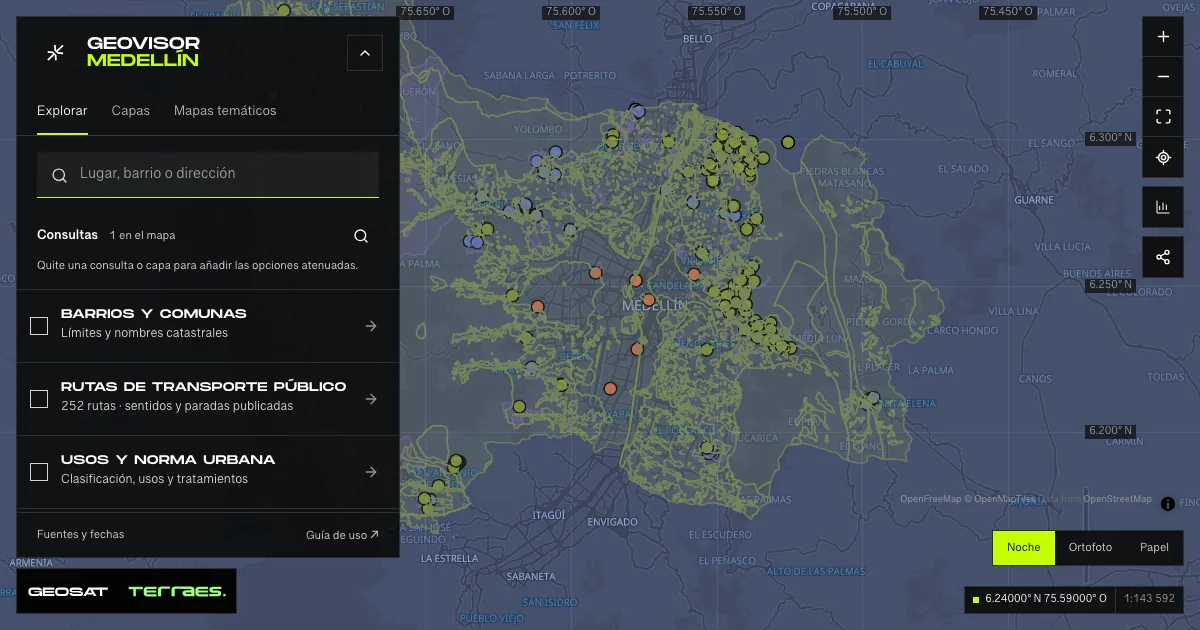
What it includes
- Relief agencies · DAGRD directory
8 map features · date not declared · Cartografía pública municipal · licencia específica no indicada
Distrito Especial de Ciencia Tecnología e Innovación de Medellín · GeoMedellín · DAGRD · Adaptación GeoSAT: selección de atributos y consulta WGS84 con nueve decimales al servicio de origen. Geometrías originales completas sin simplificación · Source checked: 2026-09-29
8 relief-agency sites published by DAGRD: the official fire department, DAGRD and six rescue and support corporations. The layer retains entity, address, district, neighborhood and one institutional phone per site; published contact names, emails, mobile numbers and fax numbers are not reproduced. Verify phones and addresses with each entity: they do not confirm operational availability or emergency response at the site.
Official source ↗Servicio público de gestión del riesgo / Public risk-management map service ↗
DAGRD · gestión del riesgo de Medellín / Medellín risk management ↗
- SIMER geotechnical monitoring
68 map features · date not declared · Cartografía pública municipal · licencia específica no indicada
Distrito Especial de Ciencia Tecnología e Innovación de Medellín · GeoMedellín · DAGRD · Adaptación GeoSAT: selección de atributos y consulta WGS84 con nueve decimales al servicio de origen. Geometrías originales completas sin simplificación · Source checked: 2026-09-29
68 SIMER (Risk Scenario Monitoring System) instruments located by DAGRD landslide team: 53 active, 14 failed and 1 not found. Each record retains instrument, status, district, neighborhood and installation and current depths in meters, plus the reading as published text with no declared unit. These are geotechnical monitoring points, not live readings or safe/unstable areas.
Official source ↗Servicio público de gestión del riesgo / Public risk-management map service ↗
DAGRD · gestión del riesgo de Medellín / Medellín risk management ↗
- DAGRD conventional studies
237 map features · date not declared · Cartografía pública municipal · licencia específica no indicada
Distrito Especial de Ciencia Tecnología e Innovación de Medellín · GeoMedellín · DAGRD · Adaptación GeoSAT: selección de atributos y consulta WGS84 con nueve decimales al servicio de origen. Geometrías originales completas sin simplificación · Source checked: 2026-09-29
237 conventional DAGRD studies from 1984 to 2023 — geological, geotechnical, hydrogeological, hydraulic, soil and structural pathology — all with Terminada status. Each polygon retains title, contract, contractor (56 distinct), type, year and territory with published codes. Types and years are retained verbatim; one record carries a code instead of a neighborhood name. These are study areas, not current diagnoses or soil suitability.
Official source ↗Servicio público de gestión del riesgo / Public risk-management map service ↗
DAGRD · gestión del riesgo de Medellín / Medellín risk management ↗
- DAGRD mitigation works
129 map features · date not declared · Cartografía pública municipal · licencia específica no indicada
Distrito Especial de Ciencia Tecnología e Innovación de Medellín · GeoMedellín · DAGRD · Adaptación GeoSAT: selección de atributos y consulta WGS84 con nueve decimales al servicio de origen. Geometrías originales completas sin simplificación · Source checked: 2026-09-29
129 civil mitigation works executed under SIMPAD-DAGRD contracts from 2016 to 2022 (no 2019 records), all with Terminada status. The service publishes 131 records, but two are excluded, with their attributes kept in the audit: one (2022 contract 4600096098) carries NaN coordinates with no location and another sits north of the municipal boundary (latitude 6.54), outside the area the viewer queries. Each point retains contract, year, purpose, contractor and executed work; one record omits district and neighborhood and another omits the work description, retained with those gaps. These are field-verified point interventions, not mitigation coverage or current area safety. The identifier field keeps its published objectid_12 name.
Official source ↗Servicio público de gestión del riesgo / Public risk-management map service ↗
DAGRD · gestión del riesgo de Medellín / Medellín risk management ↗
- Geology · seismic microzonation
2,588 map features · date not declared · Cartografía pública municipal · licencia específica no indicada
Distrito Especial de Ciencia Tecnología e Innovación de Medellín · GeoMedellín · DAGRD · Adaptación GeoSAT: selección de atributos y consulta WGS84 al servicio de origen. Geometrías simplificadas hasta 2 m para visualización, con variación de área inferior al 1 % o a 250 m² por registro; los registros que superarían ese umbral conservan la geometría original · Source checked: 2026-09-29
2,588 geological-unit polygons for the District, surveyed in the field for the Medellín and Aburrá Valley seismic microzonation with the metropolitan authority: 31 units, mostly anthropogenic fills (Qll, 1,494 polygons) and landslide deposits (Qd, 465). Each polygon retains unit and description. Geometries simplified by up to 2 m for display, with area change below 1% or 250 m² per record. Geological reference, not a parcel soil study or seismic forecast.
Official source ↗Servicio público de gestión del riesgo / Public risk-management map service ↗
DAGRD · gestión del riesgo de Medellín / Medellín risk management ↗
How to use it
- Click “Open this query” to load Relief agencies · DAGRD directory, SIMER geotechnical monitoring, DAGRD conventional studies, DAGRD mitigation works, and Geology · seismic microzonation in the viewer.
- Select a feature on the map or in the Results list to read its record with attributes, source and date.
- Build a thematic map to compare, or open statistics to analyze the loaded data.
- Share the view link or export received results with attribution and dates.
Distinguish hazard and risk conditions →
Frequently asked questions
What does “DAGRD risk management” open on the map?
Relief, monitoring, studies, works and geology: 5 layers (Relief agencies · DAGRD directory, SIMER geotechnical monitoring, DAGRD conventional studies, DAGRD mitigation works, and Geology · seismic microzonation), with 3,030 published map features.
Where do the data come from, and how can they be reused?
Layers come from Distrito Especial de Ciencia Tecnología e Innovación de Medellín · GeoMedellín · DAGRD · Adaptación GeoSAT: selección de atributos y consulta WGS84 con nueve decimales al servicio de origen. Geometrías originales completas sin simplificación and Distrito Especial de Ciencia Tecnología e Innovación de Medellín · GeoMedellín · DAGRD · Adaptación GeoSAT: selección de atributos y consulta WGS84 al servicio de origen. Geometrías simplificadas hasta 2 m para visualización, con variación de área inferior al 1 % o a 250 m² por registro; los registros que superarían ese umbral conservan la geometría original. Published licenses: Cartografía pública municipal · licencia específica no indicada. Each record retains its source and date; check the exact license before reuse.
Are the results complete?
This query loads 5 layers from reference publications by pages within the queried area, up to 5,000 map features and 8 MiB per layer. Wait for loading to finish before interpreting statistics; zoom in if the limit is exceeded. The queried area is not the complete municipal inventory.
Do I need an account or payment?
No. The Medellín geovisor is free with no account: open the query, explore, export received results and share the link. Last GeoSAT verification: 2026-09-29.