
Community preparedness in Medellín
39 points, 101 routes, 11 sirens and 13 sensors.
4 layers · 164 published map features · Distrito Especial de Ciencia Tecnología e Innovación de Medellín · GeoMedellín · Plan Municipal de Gestión del Riesgo de Desastres · Adaptación GeoSAT: selección de atributos, consulta WGS84 con nueve decimales y geometrías originales completas sin simplificar and Distrito Especial de Ciencia Tecnología e Innovación de Medellín · GeoMedellín · Plan Municipal de Gestión del Riesgo de Desastres · Adaptación GeoSAT: selección de atributos, normalización de espacios, consulta WGS84 con nueve decimales y geometrías originales completas sin simplificar
Open this query ↗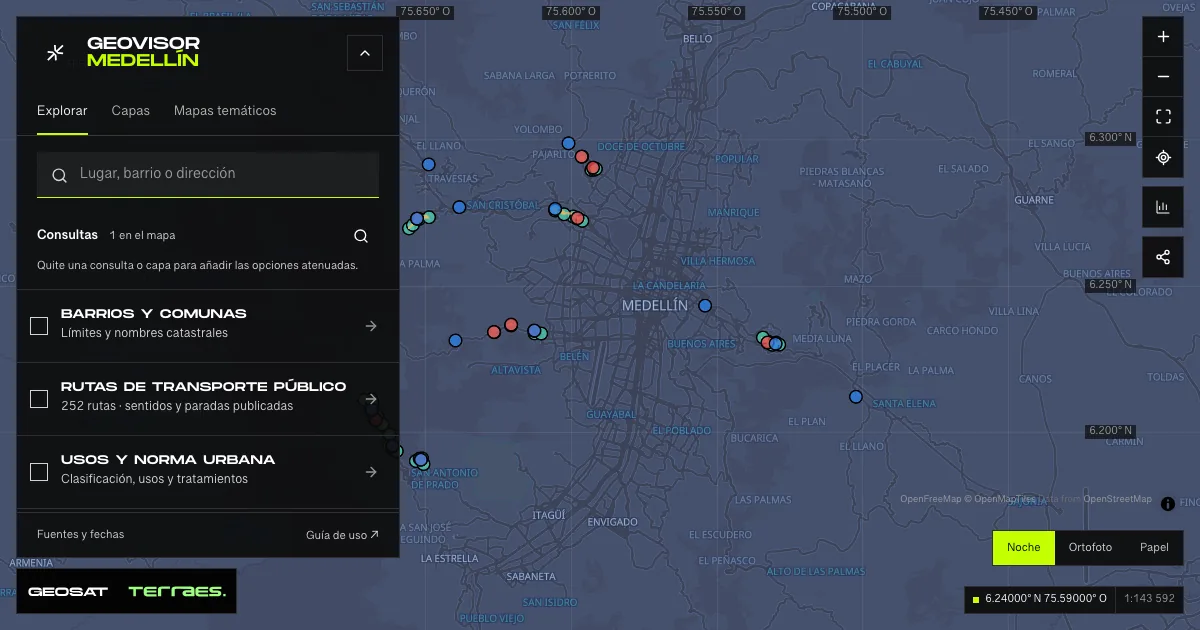
What it includes
- Meeting points · community preparedness
39 map features · date not declared · Cartografía pública municipal · licencia específica no indicada
Distrito Especial de Ciencia Tecnología e Innovación de Medellín · GeoMedellín · Plan Municipal de Gestión del Riesgo de Desastres · Adaptación GeoSAT: selección de atributos, consulta WGS84 con nueve decimales y geometrías originales completas sin simplificar · Source checked: 2026-09-29
39 meeting points across 8 districts and townships, linked to eight published stream names: the area where at-risk communities should head when a red alert is issued, per the published definition. Four records carry no point description and two also omit the stream name; they are retained with those gaps. Records publish no dates or reuse license. This is planning reference: it does not confirm that a point remains enabled, has capacity or is safe during an emergency. Always follow current DAGRD and relief-agency instructions.
Official source ↗Servicio de gestión del riesgo / Risk-management map service ↗
DAGRD · gestión del riesgo de Medellín / Medellín risk management ↗
- Evacuation routes · community preparedness
101 map features · date not declared · Cartografía pública municipal · licencia específica no indicada
Distrito Especial de Ciencia Tecnología e Innovación de Medellín · GeoMedellín · Plan Municipal de Gestión del Riesgo de Desastres · Adaptación GeoSAT: selección de atributos, consulta WGS84 con nueve decimales y geometrías originales completas sin simplificar · Source checked: 2026-09-29
101 evacuation routes: published paths to move residents toward meeting points in flood or torrent-flow risk areas. Records publish no dates or reuse license. Only 22 of the 35 point references match the point inventory verbatim, so the layers are never joined automatically. These are reference traces, not navigation: verify routes on the ground and follow current relief-agency instructions.
Official source ↗Servicio de gestión del riesgo / Risk-management map service ↗
DAGRD · gestión del riesgo de Medellín / Medellín risk management ↗
- Early-warning alarms · community sirens
11 map features · date not declared · Cartografía pública municipal · licencia específica no indicada
Distrito Especial de Ciencia Tecnología e Innovación de Medellín · GeoMedellín · Plan Municipal de Gestión del Riesgo de Desastres · Adaptación GeoSAT: selección de atributos, consulta WGS84 con nueve decimales y geometrías originales completas sin simplificar · Source checked: 2026-09-29
11 early-warning sirens installed by SIATA with the community after phase 2 of early-warning-system rollout, to announce minor or major flood surges. Each point retains SIATA name, sub-basin, district and neighborhood; sub-basin names are retained verbatim, with variants such as “La Picacha” and “Quebrada La Picacha”. Records publish no dates or reuse license. Reference locations: they do not confirm sound coverage, current operation or a live alert. During an alert, follow relief-agency instructions.
Official source ↗Servicio de gestión del riesgo / Risk-management map service ↗
DAGRD · gestión del riesgo de Medellín / Medellín risk management ↗
- SIATA level sensors
13 map features · date not declared · Cartografía pública municipal · licencia específica no indicada
Distrito Especial de Ciencia Tecnología e Innovación de Medellín · GeoMedellín · Plan Municipal de Gestión del Riesgo de Desastres · Adaptación GeoSAT: selección de atributos, normalización de espacios, consulta WGS84 con nueve decimales y geometrías originales completas sin simplificar · Source checked: 2026-09-29
13 level sensors installed and monitored by SIATA on streams with early-warning systems, measuring water depth to anticipate flood surges. SIATA name, sub-basin, district and neighborhood are retained with normalized whitespace; two names keep concatenated codes and one sub-basin repeats its name, as published by the service. Records publish no dates or reuse license. Instrument locations, not live readings: current levels are available under River and stream levels. During a flood surge, follow relief-agency instructions.
Official source ↗Servicio de gestión del riesgo / Risk-management map service ↗
DAGRD · gestión del riesgo de Medellín / Medellín risk management ↗
How to use it
- Click “Open this query” to load Meeting points · community preparedness, Evacuation routes · community preparedness, Early-warning alarms · community sirens, and SIATA level sensors in the viewer.
- Select a feature on the map or in the Results list to read its record with attributes, source and date.
- Build a thematic map to compare, or open statistics to analyze the loaded data.
- Share the view link or export received results with attribution and dates.
Distinguish hazard and risk conditions →
Frequently asked questions
What does “Community preparedness” open on the map?
39 points, 101 routes, 11 sirens and 13 sensors: 4 layers (Meeting points · community preparedness, Evacuation routes · community preparedness, Early-warning alarms · community sirens, and SIATA level sensors), with 164 published map features.
Where do the data come from, and how can they be reused?
Layers come from Distrito Especial de Ciencia Tecnología e Innovación de Medellín · GeoMedellín · Plan Municipal de Gestión del Riesgo de Desastres · Adaptación GeoSAT: selección de atributos, consulta WGS84 con nueve decimales y geometrías originales completas sin simplificar and Distrito Especial de Ciencia Tecnología e Innovación de Medellín · GeoMedellín · Plan Municipal de Gestión del Riesgo de Desastres · Adaptación GeoSAT: selección de atributos, normalización de espacios, consulta WGS84 con nueve decimales y geometrías originales completas sin simplificar. Published licenses: Cartografía pública municipal · licencia específica no indicada. Each record retains its source and date; check the exact license before reuse.
Are the results complete?
This query loads 4 layers from reference publications by pages within the queried area, up to 5,000 map features and 8 MiB per layer. Wait for loading to finish before interpreting statistics; zoom in if the limit is exceeded. The queried area is not the complete municipal inventory.
Do I need an account or payment?
No. The Medellín geovisor is free with no account: open the query, explore, export received results and share the link. Last GeoSAT verification: 2026-09-29.