
Risk-management plan scenarios in Medellín
547 polygons · scenarios and seismic susceptibility.
4 layers · 547 published map features · Distrito Especial de Ciencia Tecnología e Innovación de Medellín · GeoMedellín · Plan Municipal de Gestión del Riesgo de Desastres · Adaptación GeoSAT: selección de atributos, consulta WGS84 con nueve decimales y geometrías originales completas sin simplificar
Open this query ↗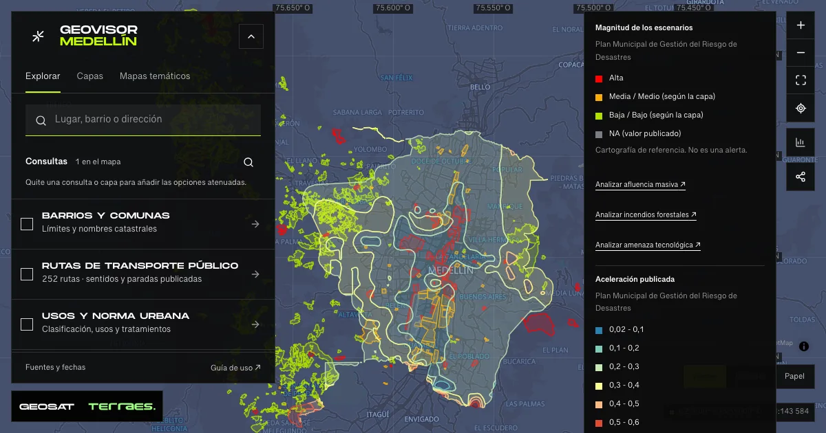
What it includes
- Mass-gathering hazard · risk management
63 map features · date not declared · Cartografía pública municipal · licencia específica no indicada
Distrito Especial de Ciencia Tecnología e Innovación de Medellín · GeoMedellín · Plan Municipal de Gestión del Riesgo de Desastres · Adaptación GeoSAT: selección de atributos, consulta WGS84 con nueve decimales y geometrías originales completas sin simplificar · Source checked: 2026-09-29
63 polygons of scenarios linked to mass-gathering events, included in the Municipal Disaster Risk Management Plan: 38 Medio, 19 Alta and 6 Bajo magnitude. Names identify venues and commercial areas, such as Coliseo Aurelio Mejía; they are not incidents, observed crowds or alerts. Records publish no dates; the service declares no reuse license. Magnitude uses masculine forms (Medio, Bajo) only in this layer.
Official source ↗Servicio de gestión del riesgo / Risk-management map service ↗
DAGRD · gestión del riesgo de Medellín / Medellín risk management ↗
- Wildfire hazard · risk management
409 map features · 2015-07-23 · CC BY-SA 4.0
Distrito Especial de Ciencia Tecnología e Innovación de Medellín · GeoMedellín · Plan Municipal de Gestión del Riesgo de Desastres · Adaptación GeoSAT: selección de atributos, consulta WGS84 con nueve decimales y geometrías originales completas sin simplificar · Source checked: 2026-09-29
409 polygons of wildfire-hazard scenarios in susceptible areas, included in the Municipal Disaster Risk Management Plan: 381 Baja, 7 Media and 21 Alta magnitude. Retains seven current land uses, including the literal <Nulo> in 41 records, and seven vegetation types. The official metadata record creates the layer on July 23, 2015 and publishes it under CC BY-SA 4.0; its 2026 revision adds no new data. These are not recorded fires, forecasts or alerts. The identifier field keeps its published id_amenanza name.
Official source ↗Servicio de gestión del riesgo / Risk-management map service ↗
Metadato oficial · CC BY-SA 4.0 / Official metadata · CC BY-SA 4.0 ↗
DAGRD · gestión del riesgo de Medellín / Medellín risk management ↗
- Technological hazard · risk management
35 map features · date not declared · Cartografía pública municipal · licencia específica no indicada
Distrito Especial de Ciencia Tecnología e Innovación de Medellín · GeoMedellín · Plan Municipal de Gestión del Riesgo de Desastres · Adaptación GeoSAT: selección de atributos, consulta WGS84 con nueve decimales y geometrías originales completas sin simplificar · Source checked: 2026-09-29
35 polygons of scenarios linked to areas with industrial conditions that may represent a hazard, included in the Municipal Disaster Risk Management Plan: 20 Media, 9 Alta and 6 NA magnitude. Names identify sectors such as Campo Amor, Tenche and Guayabal; they are not incidents, emergencies or alerts. Records publish no dates; the service declares no reuse license. The NA value is retained as published, without interpretation.
Official source ↗Servicio de gestión del riesgo / Risk-management map service ↗
DAGRD · gestión del riesgo de Medellín / Medellín risk management ↗
- Seismic susceptibility · acceleration
40 map features · date not declared · Cartografía pública municipal · licencia específica no indicada
Distrito Especial de Ciencia Tecnología e Innovación de Medellín · GeoMedellín · Plan Municipal de Gestión del Riesgo de Desastres · Adaptación GeoSAT: selección de atributos, consulta WGS84 con nueve decimales y geometrías originales completas sin simplificar · Source checked: 2026-09-29
40 seismic-susceptibility polygons from the Municipal Disaster Risk Management Plan, classified into seven published acceleration ranges with comma decimals: 1 “0,02 - 0,1”, 9 “0,1 - 0,2”, 8 “0,2 - 0,3”, 8 “0,3 - 0,4”, 6 “0,4 - 0,5”, 5 “0,5 - 0,6” and 3 “0,6 - 0,7”, with no declared unit. Records publish no dates or reuse license. Cartographic susceptibility, not a forecast, probability or structural assessment.
Official source ↗Servicio de gestión del riesgo / Risk-management map service ↗
DAGRD · gestión del riesgo de Medellín / Medellín risk management ↗
How to use it
- Click “Open this query” to load Mass-gathering hazard · risk management, Wildfire hazard · risk management, Technological hazard · risk management, and Seismic susceptibility · acceleration in the viewer.
- Select a feature on the map or in the Results list to read its record with attributes, source and date.
- Build a thematic map to compare, or open statistics to analyze the loaded data.
- Share the view link or export received results with attribution and dates.
Distinguish hazard and risk conditions →
Frequently asked questions
What does “Risk-management plan scenarios” open on the map?
547 polygons · scenarios and seismic susceptibility: 4 layers (Mass-gathering hazard · risk management, Wildfire hazard · risk management, Technological hazard · risk management, and Seismic susceptibility · acceleration), with 547 published map features.
Where do the data come from, and how can they be reused?
Layers come from Distrito Especial de Ciencia Tecnología e Innovación de Medellín · GeoMedellín · Plan Municipal de Gestión del Riesgo de Desastres · Adaptación GeoSAT: selección de atributos, consulta WGS84 con nueve decimales y geometrías originales completas sin simplificar. Published licenses: Cartografía pública municipal · licencia específica no indicada and CC BY-SA 4.0. Each record retains its source and date; check the exact license before reuse.
Are the results complete?
This query loads 4 layers from reference publications by pages within the queried area, up to 5,000 map features and 8 MiB per layer. Wait for loading to finish before interpreting statistics; zoom in if the limit is exceeded. The queried area is not the complete municipal inventory.
Do I need an account or payment?
No. The Medellín geovisor is free with no account: open the query, explore, export received results and share the link. Last GeoSAT verification: 2026-09-29.