
Land use and planning in Medellín
Compare land classification, land use and planning treatments published by Planning through the metropolitan portal.
Explore these layers ↗These are reference POT layers. They are not planning certificates and do not automatically incorporate revision proposals. Check the applicable instrument and amendments with Planning.
GeoSAT · Public mapping
One city. Many ways to read it.
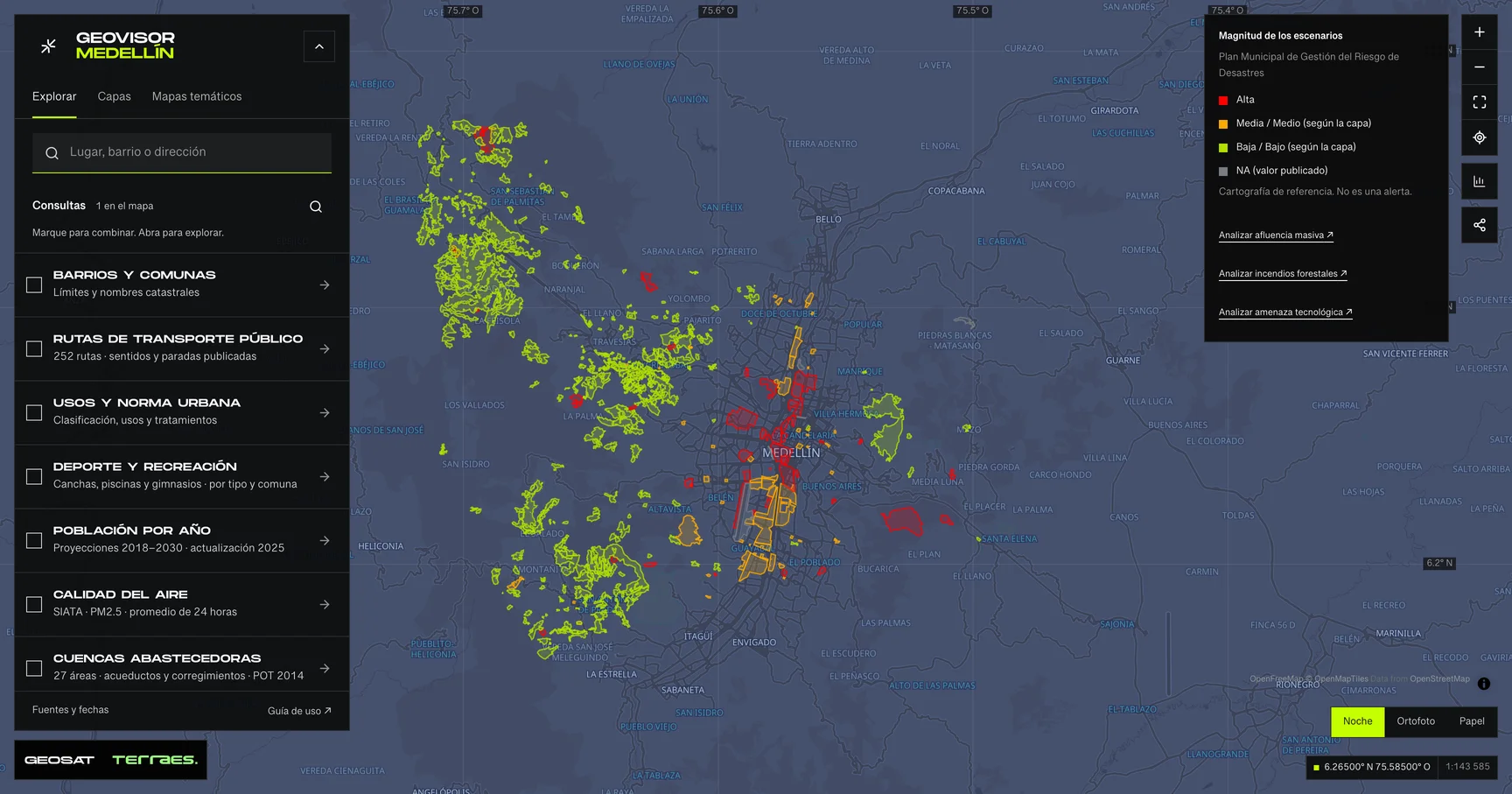
Geovisor view · Municipal Disaster Risk Management Plan scenarios, City of Medellín. Reference mapping: not alerts or events.
How to use itHow to use the map
- Open the prepared query for this theme in the viewer. Search a neighborhood or enter coordinates as latitude, longitude.
- Review enabled layers in the theme and zoom in. Detailed layers require a close scale to keep queries bounded.
- Select a feature on the map or in the Results list. Check its attributes, retrieval time and any partial-result notice.
- Choose a field and exact value to filter the layer. Export includes received results, with attribution and dates. Its coverage depends on the query scope and filters.
Frequently asked questions
What does Land use and planning include in the Medellín geovisor?
In Medellín’s Land use and planning you can explore 13 layers: Road hierarchy · 2014 plan, Rural road-corridor reserves · 2014 plan, Strategic intervention areas · 2014 plan and 10 more. Each layer states its source, date and use limits.
Can I reuse the Land use and planning data?
According to each layer’s published license: Cartografía pública municipal · licencia específica no indicada and CC BY 4.0. Check the exact license on the layer record before reuse.
How current are the Land use and planning data?
Layers declare data dates from 2014-12-17 to 2014-12-17; 5 of 13 have no verified dataset-wide date. Last GeoSAT verification: 2026-09-28.
How do I explore Land use and planning in the viewer?
Click “Explore these layers” to open the prepared Land use and planning query; review enabled layers under Layers. Filter by exact field and value, select features to read their records, and export received results with attribution and dates.
Who publishes the Land use and planning data?
Layers come from Distrito Especial de Ciencia Tecnología e Innovación de Medellín · GeoMedellín · Adaptación GeoSAT: selección y nombres de atributos; categorías de dominios y leyendas oficiales; geometría WGS84 del servicio, sin simplificación, con al menos siete decimales, Distrito Especial de Ciencia Tecnología e Innovación de Medellín · GeoMedellín · Departamento Administrativo de Planeación · Adaptación GeoSAT: atributos seleccionados; transformación WGS84 del servicio; simplificación de hasta 0,5 m con preservación de componentes y huecos; precisión de al menos siete decimales, Distrito Especial de Ciencia Tecnología e Innovación de Medellín · GeoMedellín · Departamento Administrativo de Planeación · Subdirección de Planeación Territorial y Estratégica de Ciudad · Unidad de Planificación Territorial · Adaptación GeoSAT: selección de atributos y estados de la leyenda oficial; geometría WGS84 del servicio sin simplificación, and Distrito Especial de Ciencia, Tecnología e Innovación de Medellín · Planeación · servicio AMVA, retrieved and adapted by GeoSAT with per-record attribution and provenance.
Which other themes can I explore?
Other themes in the Medellín geovisor: Metro, cableways and tram, Road infrastructure and taxi stands, and Walking and tactical urbanism.
Sources, dates and limits
Each source’s verification date appears in the table. Retrieval time is not the data update date. Small city-wide layers use the full extent; larger layers depend on the visible area. Reference publications retain their original retrieval date. Each page contains up to 500 features: up to 2 MiB for external services and 4 MiB for local publications. Reference publications load matching pages, up to 5,000 features and 8 MiB per query. External services may return partial samples, identified in the viewer.
| Layer and source | Data date | Reuse |
|---|---|---|
| Road hierarchy · 2014 planDistrito Especial de Ciencia Tecnología e Innovación de Medellín · GeoMedellín · Adaptación GeoSAT: selección y nombres de atributos; categorías de dominios y leyendas oficiales; geometría WGS84 del servicio, sin simplificación, con al menos siete decimales 1,030 road-hierarchy paths, including railway, with urban or rural classification and planning statuses “Existente”, “Ampliación” and “Proyectado”. All publish adoption and update dates of December 17, 2014. The archive retains connections outside Medellín; queries return paths intersecting the requested extent. This does not show traffic, closures, open lanes or current navigability. Geometries are neither clipped nor dissolved for length sums. The service declares no specific reuse license. | 2014-12-17Source checked: | Cartografía pública municipal · licencia específica no indicada |
| Rural road-corridor reserves · 2014 planDistrito Especial de Ciencia Tecnología e Innovación de Medellín · GeoMedellín · Adaptación GeoSAT: selección y nombres de atributos; categorías de dominios y leyendas oficiales; geometría WGS84 del servicio, sin simplificación, con al menos siete decimales Four rural reservation or exclusion corridor polygons, with adoption and update dates of December 17, 2014. Published names and complete boundaries are retained. They are not drivable road widths, certified affected parcels or completed works; applying restrictions requires the plan and relevant instruments. The service declares no specific reuse license. | 2014-12-17Source checked: | Cartografía pública municipal · licencia específica no indicada |
| Strategic intervention areas · 2014 planDistrito Especial de Ciencia Tecnología e Innovación de Medellín · GeoMedellín · Departamento Administrativo de Planeación · Adaptación GeoSAT: atributos seleccionados; transformación WGS84 del servicio; simplificación de hasta 0,5 m con preservación de componentes y huecos; precisión de al menos siete decimales Twelve strategic intervention polygons from the land-use plan adopted through Agreement 48 of 2014: MEDRío, the urban-rural edge and cross-city areas. Published names and classifications are retained. Record adoption and update dates are December 17, 2014; retrieval in 2026 does not update the plan or establish project delivery. These are not live works or regulatory certification. The public service declares no specific reuse license. | 2014-12-17Source checked: | Cartografía pública municipal · licencia específica no indicada |
| Urban and rural centers · 2014 planDistrito Especial de Ciencia Tecnología e Innovación de Medellín · GeoMedellín · Departamento Administrativo de Planeación · Adaptación GeoSAT: atributos seleccionados; transformación WGS84 del servicio; simplificación de hasta 0,5 m con preservación de componentes y huecos; precisión de al menos siete decimales 78 centers from the 2014 land-use plan with published hierarchy, character, order, action and status. The service’s three representations contain the same 78 IDs and attributes; records are included once, with both urban and rural hierarchies. “Consolidada” and other statuses describe that plan, not a current assessment. Adoption and update: December 17, 2014. Boundaries are not neighborhoods or commercial catchments. The public service declares no specific reuse license. | 2014-12-17Source checked: | Cartografía pública municipal · licencia específica no indicada |
| Housing density, floor-area ratio and height · 2014 planDistrito Especial de Ciencia Tecnología e Innovación de Medellín · GeoMedellín · Departamento Administrativo de Planeación · Adaptación GeoSAT: atributos seleccionados; transformación WGS84 del servicio; simplificación de hasta 0,5 m con preservación de componentes y huecos; precisión de al menos siete decimales 386 municipal urban and urban-expansion polygons, with published adoption and update dates of December 17, 2014. Density, floor-area-ratio and height services repeat the same IDs and attributes and are included once. Their scope differs from the metropolitan treatment source’s 522 records, retained separately. Maximum housing density: dwellings per hectare; floor-area ratio: permitted floor m² per land m²; both use net land area except Development treatment, which uses gross area. Numeric height is in floors. “N/A” and “Variable 1/2/3” remain categories and are not converted to zero. These are published planning parameters, not population, existing dwellings or measured building heights. Means describe polygons with values, without area weighting; they do not calculate total development capacity. Application depends on Agreement 48 of 2014 and applicable rules; the viewer does not certify a property’s development rights. The service declares no specific reuse license. Densidad: leyenda / Density legend ↗ Índice de construcción / Floor-area ratio ↗ Altura normativa / Planning height ↗ Acuerdo 48 de 2014: artículos 271, 273, 280 y 295 / Adopted planning definitions ↗ | 2014-12-17Source checked: | Cartografía pública municipal · licencia específica no indicada |
| Rural agricultural district · 2014 planDistrito Especial de Ciencia Tecnología e Innovación de Medellín · GeoMedellín · Departamento Administrativo de Planeación · Adaptación GeoSAT: atributos seleccionados; transformación WGS84 del servicio; simplificación de hasta 0,5 m con preservación de componentes y huecos; precisión de al menos siete decimales 69 polygon records of the rural agricultural district in the 2014 plan, organized by rural district and treatment code; these are not 69 distinct districts. Every geometry component and hole is retained. Published adoption and update: December 17, 2014. These are not parcels, farms, current crops or cadastral boundaries. The public service declares no specific reuse license. | 2014-12-17Source checked: | Cartografía pública municipal · licencia específica no indicada |
| Rural planning units · 2014 planDistrito Especial de Ciencia Tecnología e Innovación de Medellín · GeoMedellín · Departamento Administrativo de Planeación · Adaptación GeoSAT: atributos seleccionados; transformación WGS84 del servicio; simplificación de hasta 0,5 m con preservación de componentes y huecos; precisión de al menos siete decimales 22 rural planning unit polygons with names, codes, classifications and categories published in the 2014 land-use plan. Adoption and update dates are December 17, 2014. Boundaries identify planning instruments; they do not establish subsequent individual adoption, delivery or current status. These are not cadastral boundaries. The public service declares no specific reuse license. | 2014-12-17Source checked: | Cartografía pública municipal · licencia específica no indicada |
| Transport corridors · 2014 land-use planDistrito Especial de Ciencia Tecnología e Innovación de Medellín · GeoMedellín · Departamento Administrativo de Planeación · Subdirección de Planeación Territorial y Estratégica de Ciudad · Unidad de Planificación Territorial · Adaptación GeoSAT: selección de atributos y estados de la leyenda oficial; geometría WGS84 del servicio sin simplificación 94 mapped passenger-transport corridor records from the land-use plan adopted through Agreement 48 of 2014; these are not 94 distinct lines. Published adoption and update dates are December 17, 2014. The official legend classified nine records as existing and 85 as proposed or under study: these are categories of that plan, not a current assessment. They do not establish operations, frequencies, stops, traffic or confirmed project delivery. Published names and paths remain unchanged, including overlapping segments, multipart features and portions beyond the initial viewer extent; summing full lengths does not yield a municipal total or travel itinerary. The public service declares no specific reuse license. Leyenda oficial / Official legend ↗ Cartografía protocolizada POT 2014 / Protocolized 2014 planning map ↗ | 2014-12-17Source checked: | Cartografía pública municipal · licencia específica no indicada |
| Land classificationDistrito Especial de Ciencia, Tecnología e Innovación de Medellín · Planeación · servicio AMVA | No dataset-wide date declared; check individual recordsSource checked: | CC BY 4.0 |
| Urban land useDistrito Especial de Ciencia, Tecnología e Innovación de Medellín · Planeación · servicio AMVA | No dataset-wide date declared; check individual recordsSource checked: | CC BY 4.0 |
| Rural land useDistrito Especial de Ciencia, Tecnología e Innovación de Medellín · Planeación · servicio AMVA | No dataset-wide date declared; check individual recordsSource checked: | CC BY 4.0 |
| POT planning treatmentsDistrito Especial de Ciencia, Tecnología e Innovación de Medellín · Planeación · servicio AMVA | No dataset-wide date declared; check individual recordsSource checked: | CC BY 4.0 |
| Partial plansDistrito Especial de Ciencia, Tecnología e Innovación de Medellín · Planeación · servicio AMVA | No dataset-wide date declared; check individual recordsSource checked: | CC BY 4.0 |
Display transformations and adaptations are described for each source; precision and methods differ between sources. Obtain official mapping if you need surveying accuracy or documents with administrative validity.