
Hazards and risk in Medellín
Explore 716 flood-hazard and 2,376 landslide-hazard polygons using the four degrees in the official land-use-plan legend: very low, low, medium and high. The torrent-flow layer adds 115 polygons with its own three-degree blue legend. Three Municipal Disaster Risk Management Plan layers add 507 scenario polygons: 63 mass-gathering, 409 wildfire and 35 technological-hazard records, each with its published magnitude vocabulary; seismic susceptibility from the same plan adds 40 polygons in seven acceleration ranges. Community preparedness adds 39 meeting points and 101 evacuation routes as planning reference, never joined automatically, plus 11 SIATA sirens and 13 level sensors. DAGRD contributes its 8-agency relief directory, 68 geotechnical monitoring instruments, 237 studies from 1984 to 2023, 129 mitigation works from 2016 to 2022 and 2,588 geological-unit polygons. Also inspect areas with risk conditions and non-mitigable high risk in their separate layer. Review categories, dates and geometry while distinguishing hazard, risk and recorded events.
Explore these layers ↗The hazard layer refers to the land-use plan adopted under Agreement 48 of 2014. Flood and landslide records state an April 30, 2026 update; torrent-flow records include April and July 2026 dates; metadata retains a 2016 revision and an earlier count. Risk conditions reference June 18, 2021. Of the 507 risk-management plan scenarios, wildfire is published under CC BY-SA 4.0 with 2015 creation; mass gatherings and technological hazard publish no dates or license. Preparedness points and routes also publish no dates or license, and confirm neither capacity nor safety during an emergency. DAGRD sirens, sensors, instruments, studies, works, relief sites and geological units also publish no dates or license; their readings, statuses and phones are references, not diagnoses, operational availability or current assessments. These are different sources and dates. They are not warnings, events, property assessments or a complete hazard inventory. Consult Planning and the official adopted map for authoritative decisions.
GeoSAT · Public mapping
One city. Many ways to read it.
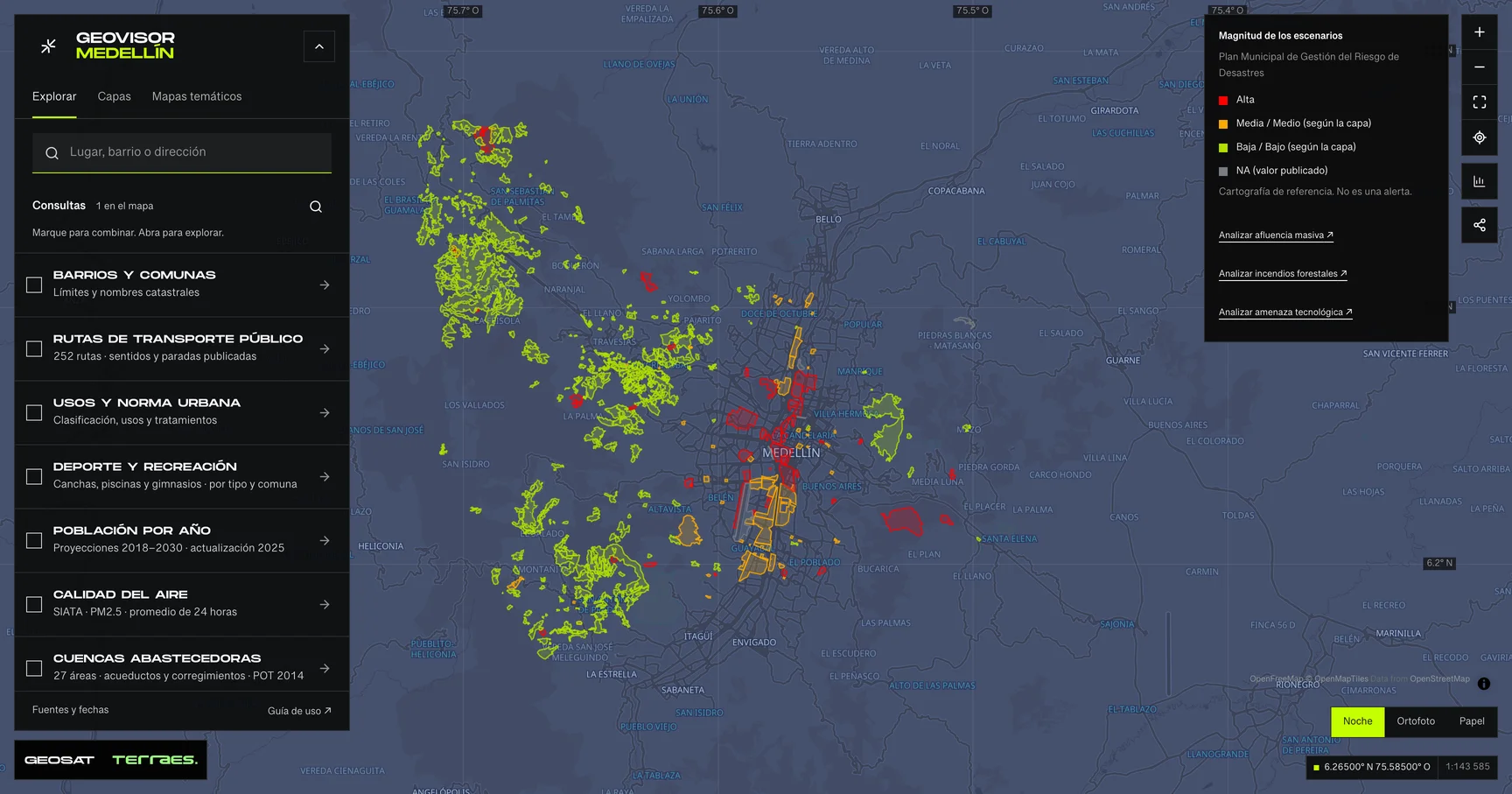
Geovisor view · Municipal Disaster Risk Management Plan scenarios, City of Medellín. Reference mapping: not alerts or events.
How to use itHow to use the map
- Open the prepared query for this theme in the viewer. Search a neighborhood or enter coordinates as latitude, longitude.
- Review enabled layers in the theme and zoom in. Detailed layers require a close scale to keep queries bounded.
- Select a feature on the map or in the Results list. Check its attributes, retrieval time and any partial-result notice.
- Choose a field and exact value to filter the layer. Export includes received results, with attribution and dates. Its coverage depends on the query scope and filters.
Frequently asked questions
What does Hazards and risk include in the Medellín geovisor?
In Medellín’s Hazards and risk you can explore 17 layers: Landslide hazard · land-use plan, Flood hazard · land-use plan, Torrent-flow hazard · land-use plan and 14 more. Each layer states its source, date and use limits.
Can I reuse the Hazards and risk data?
According to each layer’s published license: CC BY-SA 4.0, Cartografía pública municipal · licencia específica no indicada, and CC BY 4.0. Check the exact license on the layer record before reuse.
How current are the Hazards and risk data?
Layers declare data dates from 2015-07-23 to 2026-04-30; 14 of 17 have no verified dataset-wide date. Last GeoSAT verification: 2026-09-29.
How do I explore Hazards and risk in the viewer?
Click “Explore these layers” to open the prepared Hazards and risk query; review enabled layers under Layers. Filter by exact field and value, select features to read their records, and export received results with attribution and dates.
Who publishes the Hazards and risk data?
Layers come from Distrito Especial de Ciencia Tecnología e Innovación de Medellín · GeoMedellín · Departamento Administrativo de Planeación · Subdirección de Planeación Territorial y Estratégica de Ciudad · Adaptación GeoSAT: selección de atributos, fechas UTC ISO, WGS84, reparación de siete anillos y simplificación topológica con tolerancia de 1 m y variación de área inferior al 0,5 % por registro, Distrito de Medellín · GeoMedellín · Departamento Administrativo de Planeación · Adaptación GeoSAT: atributos seleccionados, fechas UTC ISO, WGS84 y simplificación topológica hasta 1 m, conservando componentes y huecos, con variación de área inferior al 0,5 % por registro, Distrito Especial de Ciencia Tecnología e Innovación de Medellín · GeoMedellín · Plan Municipal de Gestión del Riesgo de Desastres · Adaptación GeoSAT: selección de atributos, consulta WGS84 con nueve decimales y geometrías originales completas sin simplificar, Distrito Especial de Ciencia Tecnología e Innovación de Medellín · GeoMedellín · Plan Municipal de Gestión del Riesgo de Desastres · Adaptación GeoSAT: selección de atributos, normalización de espacios, consulta WGS84 con nueve decimales y geometrías originales completas sin simplificar, Distrito Especial de Ciencia Tecnología e Innovación de Medellín · GeoMedellín · DAGRD · Adaptación GeoSAT: selección de atributos y consulta WGS84 con nueve decimales al servicio de origen. Geometrías originales completas sin simplificación, Distrito Especial de Ciencia Tecnología e Innovación de Medellín · GeoMedellín · DAGRD · Adaptación GeoSAT: selección de atributos y consulta WGS84 al servicio de origen. Geometrías simplificadas hasta 2 m para visualización, con variación de área inferior al 1 % o a 250 m² por registro; los registros que superarían ese umbral conservan la geometría original, and Distrito Especial de Ciencia, Tecnología e Innovación de Medellín · Planeación · servicio AMVA, retrieved and adapted by GeoSAT with per-record attribution and provenance.
Which other themes can I explore?
Other themes in the Medellín geovisor: Metro, cableways and tram, Road infrastructure and taxi stands, and Walking and tactical urbanism.
Sources, dates and limits
Each source’s verification date appears in the table. Retrieval time is not the data update date. Small city-wide layers use the full extent; larger layers depend on the visible area. Reference publications retain their original retrieval date. Each page contains up to 500 features: up to 2 MiB for external services and 4 MiB for local publications. Reference publications load matching pages, up to 5,000 features and 8 MiB per query. External services may return partial samples, identified in the viewer.
| Layer and source | Data date | Reuse |
|---|---|---|
| Landslide hazard · land-use planDistrito Especial de Ciencia Tecnología e Innovación de Medellín · GeoMedellín · Departamento Administrativo de Planeación · Subdirección de Planeación Territorial y Estratégica de Ciudad · Adaptación GeoSAT: selección de atributos, fechas UTC ISO, WGS84, reparación de siete anillos y simplificación topológica con tolerancia de 1 m y variación de área inferior al 0,5 % por registro 2,376 polygons of very low, low, medium and high hazard; these are not events, affected homes or alerts. Reference to the land-use plan adopted by Agreement 48 of 2014. Records state adoption on December 17, 2014 and update on April 30, 2026; metadata retains a 2016 revision and an earlier count of 2,282. Record dates are shown without assigning a single dataset date. Geometry is adapted for display and does not certify property risk, stability or safety. Consult the official adopted map and Planning for authoritative information. Areas with risk conditions are a separate layer. Fuente de los polígonos / Polygon source ↗ Mapa 05 y leyenda oficial / Map 05 and official legend ↗ | No dataset-wide date declared; check individual recordsSource checked: | CC BY-SA 4.0 |
| Flood hazard · land-use planDistrito de Medellín · GeoMedellín · Departamento Administrativo de Planeación · Adaptación GeoSAT: atributos seleccionados, fechas UTC ISO, WGS84 y simplificación topológica hasta 1 m, conservando componentes y huecos, con variación de área inferior al 0,5 % por registro 716 polygons: 197 very low, 123 low, 259 medium and 137 high hazard. Records state adoption on December 17, 2014 and update on April 30, 2026. These are planning hazard degrees, not observed floods, forecasts, warnings, exposed populations or property assessments. Torrent-flow hazard is not included. Consult Planning and the official adopted map for authoritative decisions. The service declares no specific reuse license. | 2026-04-30Source checked: | Cartografía pública municipal · licencia específica no indicada |
| Torrent-flow hazard · land-use planDistrito de Medellín · GeoMedellín · Departamento Administrativo de Planeación · Adaptación GeoSAT: atributos seleccionados, fechas UTC ISO, WGS84 y simplificación topológica hasta 1 m, conservando componentes y huecos, con variación de área inferior al 0,5 % por registro 115 polygons: 52 low, 32 medium and 31 high hazard. Reference to the land-use plan adopted by Agreement 48 of 2014, distinct from flood hazard. All records state adoption on December 17, 2014; 64 state an April 30, 2026 update and 51 a July 17, 2026 update. These dates and published codes remain unchanged, including alternative codes for the same category. The official layer title mentions high hazard, but its data and legend include all three degrees. These are not observed events, forecasts, warnings or property safety assessments. Consult Planning and the official adopted map for authoritative decisions. The service declares no specific reuse license. | No dataset-wide date declared; check individual recordsSource checked: | Cartografía pública municipal · licencia específica no indicada |
| Mass-gathering hazard · risk managementDistrito Especial de Ciencia Tecnología e Innovación de Medellín · GeoMedellín · Plan Municipal de Gestión del Riesgo de Desastres · Adaptación GeoSAT: selección de atributos, consulta WGS84 con nueve decimales y geometrías originales completas sin simplificar 63 polygons of scenarios linked to mass-gathering events, included in the Municipal Disaster Risk Management Plan: 38 Medio, 19 Alta and 6 Bajo magnitude. Names identify venues and commercial areas, such as Coliseo Aurelio Mejía; they are not incidents, observed crowds or alerts. Records publish no dates; the service declares no reuse license. Magnitude uses masculine forms (Medio, Bajo) only in this layer. Servicio de gestión del riesgo / Risk-management map service ↗ DAGRD · gestión del riesgo de Medellín / Medellín risk management ↗ | No dataset-wide date declared; check individual recordsSource checked: | Cartografía pública municipal · licencia específica no indicada |
| Wildfire hazard · risk managementDistrito Especial de Ciencia Tecnología e Innovación de Medellín · GeoMedellín · Plan Municipal de Gestión del Riesgo de Desastres · Adaptación GeoSAT: selección de atributos, consulta WGS84 con nueve decimales y geometrías originales completas sin simplificar 409 polygons of wildfire-hazard scenarios in susceptible areas, included in the Municipal Disaster Risk Management Plan: 381 Baja, 7 Media and 21 Alta magnitude. Retains seven current land uses, including the literal <Nulo> in 41 records, and seven vegetation types. The official metadata record creates the layer on July 23, 2015 and publishes it under CC BY-SA 4.0; its 2026 revision adds no new data. These are not recorded fires, forecasts or alerts. The identifier field keeps its published id_amenanza name. Servicio de gestión del riesgo / Risk-management map service ↗ Metadato oficial · CC BY-SA 4.0 / Official metadata · CC BY-SA 4.0 ↗ DAGRD · gestión del riesgo de Medellín / Medellín risk management ↗ | 2015-07-23Source checked: | CC BY-SA 4.0 |
| Technological hazard · risk managementDistrito Especial de Ciencia Tecnología e Innovación de Medellín · GeoMedellín · Plan Municipal de Gestión del Riesgo de Desastres · Adaptación GeoSAT: selección de atributos, consulta WGS84 con nueve decimales y geometrías originales completas sin simplificar 35 polygons of scenarios linked to areas with industrial conditions that may represent a hazard, included in the Municipal Disaster Risk Management Plan: 20 Media, 9 Alta and 6 NA magnitude. Names identify sectors such as Campo Amor, Tenche and Guayabal; they are not incidents, emergencies or alerts. Records publish no dates; the service declares no reuse license. The NA value is retained as published, without interpretation. Servicio de gestión del riesgo / Risk-management map service ↗ DAGRD · gestión del riesgo de Medellín / Medellín risk management ↗ | No dataset-wide date declared; check individual recordsSource checked: | Cartografía pública municipal · licencia específica no indicada |
| Seismic susceptibility · accelerationDistrito Especial de Ciencia Tecnología e Innovación de Medellín · GeoMedellín · Plan Municipal de Gestión del Riesgo de Desastres · Adaptación GeoSAT: selección de atributos, consulta WGS84 con nueve decimales y geometrías originales completas sin simplificar 40 seismic-susceptibility polygons from the Municipal Disaster Risk Management Plan, classified into seven published acceleration ranges with comma decimals: 1 “0,02 - 0,1”, 9 “0,1 - 0,2”, 8 “0,2 - 0,3”, 8 “0,3 - 0,4”, 6 “0,4 - 0,5”, 5 “0,5 - 0,6” and 3 “0,6 - 0,7”, with no declared unit. Records publish no dates or reuse license. Cartographic susceptibility, not a forecast, probability or structural assessment. Servicio de gestión del riesgo / Risk-management map service ↗ DAGRD · gestión del riesgo de Medellín / Medellín risk management ↗ | No dataset-wide date declared; check individual recordsSource checked: | Cartografía pública municipal · licencia específica no indicada |
| Meeting points · community preparednessDistrito Especial de Ciencia Tecnología e Innovación de Medellín · GeoMedellín · Plan Municipal de Gestión del Riesgo de Desastres · Adaptación GeoSAT: selección de atributos, consulta WGS84 con nueve decimales y geometrías originales completas sin simplificar 39 meeting points across 8 districts and townships, linked to eight published stream names: the area where at-risk communities should head when a red alert is issued, per the published definition. Four records carry no point description and two also omit the stream name; they are retained with those gaps. Records publish no dates or reuse license. This is planning reference: it does not confirm that a point remains enabled, has capacity or is safe during an emergency. Always follow current DAGRD and relief-agency instructions. Servicio de gestión del riesgo / Risk-management map service ↗ DAGRD · gestión del riesgo de Medellín / Medellín risk management ↗ | No dataset-wide date declared; check individual recordsSource checked: | Cartografía pública municipal · licencia específica no indicada |
| Evacuation routes · community preparednessDistrito Especial de Ciencia Tecnología e Innovación de Medellín · GeoMedellín · Plan Municipal de Gestión del Riesgo de Desastres · Adaptación GeoSAT: selección de atributos, consulta WGS84 con nueve decimales y geometrías originales completas sin simplificar 101 evacuation routes: published paths to move residents toward meeting points in flood or torrent-flow risk areas. Records publish no dates or reuse license. Only 22 of the 35 point references match the point inventory verbatim, so the layers are never joined automatically. These are reference traces, not navigation: verify routes on the ground and follow current relief-agency instructions. Servicio de gestión del riesgo / Risk-management map service ↗ DAGRD · gestión del riesgo de Medellín / Medellín risk management ↗ | No dataset-wide date declared; check individual recordsSource checked: | Cartografía pública municipal · licencia específica no indicada |
| Early-warning alarms · community sirensDistrito Especial de Ciencia Tecnología e Innovación de Medellín · GeoMedellín · Plan Municipal de Gestión del Riesgo de Desastres · Adaptación GeoSAT: selección de atributos, consulta WGS84 con nueve decimales y geometrías originales completas sin simplificar 11 early-warning sirens installed by SIATA with the community after phase 2 of early-warning-system rollout, to announce minor or major flood surges. Each point retains SIATA name, sub-basin, district and neighborhood; sub-basin names are retained verbatim, with variants such as “La Picacha” and “Quebrada La Picacha”. Records publish no dates or reuse license. Reference locations: they do not confirm sound coverage, current operation or a live alert. During an alert, follow relief-agency instructions. Servicio de gestión del riesgo / Risk-management map service ↗ DAGRD · gestión del riesgo de Medellín / Medellín risk management ↗ | No dataset-wide date declared; check individual recordsSource checked: | Cartografía pública municipal · licencia específica no indicada |
| SIATA level sensorsDistrito Especial de Ciencia Tecnología e Innovación de Medellín · GeoMedellín · Plan Municipal de Gestión del Riesgo de Desastres · Adaptación GeoSAT: selección de atributos, normalización de espacios, consulta WGS84 con nueve decimales y geometrías originales completas sin simplificar 13 level sensors installed and monitored by SIATA on streams with early-warning systems, measuring water depth to anticipate flood surges. SIATA name, sub-basin, district and neighborhood are retained with normalized whitespace; two names keep concatenated codes and one sub-basin repeats its name, as published by the service. Records publish no dates or reuse license. Instrument locations, not live readings: current levels are available under River and stream levels. During a flood surge, follow relief-agency instructions. Servicio de gestión del riesgo / Risk-management map service ↗ DAGRD · gestión del riesgo de Medellín / Medellín risk management ↗ | No dataset-wide date declared; check individual recordsSource checked: | Cartografía pública municipal · licencia específica no indicada |
| Relief agencies · DAGRD directoryDistrito Especial de Ciencia Tecnología e Innovación de Medellín · GeoMedellín · DAGRD · Adaptación GeoSAT: selección de atributos y consulta WGS84 con nueve decimales al servicio de origen. Geometrías originales completas sin simplificación 8 relief-agency sites published by DAGRD: the official fire department, DAGRD and six rescue and support corporations. The layer retains entity, address, district, neighborhood and one institutional phone per site; published contact names, emails, mobile numbers and fax numbers are not reproduced. Verify phones and addresses with each entity: they do not confirm operational availability or emergency response at the site. Servicio público de gestión del riesgo / Public risk-management map service ↗ DAGRD · gestión del riesgo de Medellín / Medellín risk management ↗ | No dataset-wide date declared; check individual recordsSource checked: | Cartografía pública municipal · licencia específica no indicada |
| SIMER geotechnical monitoringDistrito Especial de Ciencia Tecnología e Innovación de Medellín · GeoMedellín · DAGRD · Adaptación GeoSAT: selección de atributos y consulta WGS84 con nueve decimales al servicio de origen. Geometrías originales completas sin simplificación 68 SIMER (Risk Scenario Monitoring System) instruments located by DAGRD landslide team: 53 active, 14 failed and 1 not found. Each record retains instrument, status, district, neighborhood and installation and current depths in meters, plus the reading as published text with no declared unit. These are geotechnical monitoring points, not live readings or safe/unstable areas. Servicio público de gestión del riesgo / Public risk-management map service ↗ DAGRD · gestión del riesgo de Medellín / Medellín risk management ↗ | No dataset-wide date declared; check individual recordsSource checked: | Cartografía pública municipal · licencia específica no indicada |
| DAGRD conventional studiesDistrito Especial de Ciencia Tecnología e Innovación de Medellín · GeoMedellín · DAGRD · Adaptación GeoSAT: selección de atributos y consulta WGS84 con nueve decimales al servicio de origen. Geometrías originales completas sin simplificación 237 conventional DAGRD studies from 1984 to 2023 — geological, geotechnical, hydrogeological, hydraulic, soil and structural pathology — all with Terminada status. Each polygon retains title, contract, contractor (56 distinct), type, year and territory with published codes. Types and years are retained verbatim; one record carries a code instead of a neighborhood name. These are study areas, not current diagnoses or soil suitability. Servicio público de gestión del riesgo / Public risk-management map service ↗ DAGRD · gestión del riesgo de Medellín / Medellín risk management ↗ | No dataset-wide date declared; check individual recordsSource checked: | Cartografía pública municipal · licencia específica no indicada |
| DAGRD mitigation worksDistrito Especial de Ciencia Tecnología e Innovación de Medellín · GeoMedellín · DAGRD · Adaptación GeoSAT: selección de atributos y consulta WGS84 con nueve decimales al servicio de origen. Geometrías originales completas sin simplificación 129 civil mitigation works executed under SIMPAD-DAGRD contracts from 2016 to 2022 (no 2019 records), all with Terminada status. The service publishes 131 records, but two are excluded, with their attributes kept in the audit: one (2022 contract 4600096098) carries NaN coordinates with no location and another sits north of the municipal boundary (latitude 6.54), outside the area the viewer queries. Each point retains contract, year, purpose, contractor and executed work; one record omits district and neighborhood and another omits the work description, retained with those gaps. These are field-verified point interventions, not mitigation coverage or current area safety. The identifier field keeps its published objectid_12 name. Servicio público de gestión del riesgo / Public risk-management map service ↗ DAGRD · gestión del riesgo de Medellín / Medellín risk management ↗ | No dataset-wide date declared; check individual recordsSource checked: | Cartografía pública municipal · licencia específica no indicada |
| Geology · seismic microzonationDistrito Especial de Ciencia Tecnología e Innovación de Medellín · GeoMedellín · DAGRD · Adaptación GeoSAT: selección de atributos y consulta WGS84 al servicio de origen. Geometrías simplificadas hasta 2 m para visualización, con variación de área inferior al 1 % o a 250 m² por registro; los registros que superarían ese umbral conservan la geometría original 2,588 geological-unit polygons for the District, surveyed in the field for the Medellín and Aburrá Valley seismic microzonation with the metropolitan authority: 31 units, mostly anthropogenic fills (Qll, 1,494 polygons) and landslide deposits (Qd, 465). Each polygon retains unit and description. Geometries simplified by up to 2 m for display, with area change below 1% or 250 m² per record. Geological reference, not a parcel soil study or seismic forecast. Servicio público de gestión del riesgo / Public risk-management map service ↗ DAGRD · gestión del riesgo de Medellín / Medellín risk management ↗ | No dataset-wide date declared; check individual recordsSource checked: | Cartografía pública municipal · licencia específica no indicada |
| Risk conditionsDistrito Especial de Ciencia, Tecnología e Innovación de Medellín · Planeación · servicio AMVA | 2021-06-18Source checked: | CC BY 4.0 |
Display transformations and adaptations are described for each source; precision and methods differ between sources. Obtain official mapping if you need surveying accuracy or documents with administrative validity.